Glenorchy is on the west side of the Derwent River immediately north of Hobart. It is part of metropolitan Hobart andi s a separate municipality of 120 sq. km., comprising the original Glenorchy township and several suburbs.
Land grants in the Glenorchy area began in 1804. By the 1820s it was occupied by farms and was a place of rural retreat from Hobart. In 1833 a Congregational Church and a private school were opened there. The town’s name is thought to have been given by Governor Lachlan Macquarie in 1811 after his wife’s family home in Scotland.
By 1864, when Glenorchy was proclaimed a municipality, it had four churches,a school, four hotels and a tannery. There were also the Rosetta Seminaryand the Rosetta jam factory, which have bestowed their name on the suburb of Rosetta. A coach road ran to Hobart and a ferry across the Derwent Riverwent to Risdon.
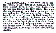
Orcharding became a significant industry, with the first cool store being built in the 1880s. Glenorchy’s hills and streams became an attraction fortourists, their coolness bringing relief from heavy clothes in summer heat.German farming immigrants settled about 10 km. west of Glenorchy at Bismark and Glenlusk. The village-like township was described in The Australian Handbook, 1875, as –

The railway had been connected to Glenorchy in the 1870s, and the connection by tram to Hobart came in 1893. Settlement and farming continued, and a branch railway line was built to what became Glenorchy’s main recreation venue, the racecourse at Elwick (now Goodwood). The Australian Handbook’s description in 1904 was –

After the first world war the Glenorchy district attracted two large industrial plants – the Electrolytic Zinc Company at Lutana, opposite Risdon,and the Cadbury chocolate factory at Claremont at the northern end of the Glenorchy municipality. Industrial development became more important inthe 1920s as apple prices slumped, and orchards at Moonah were subdivided for housing. Glenorchy began to merge with metropolitan Hobart.
In 1936 the Auditor-General reported on the municipality’s finances,resulting in the Government appointing a three-man commission to run the Council for six years. Their time coincided with business expansion in Moonah, which overtook Glenorchy township. During the postwar years the Glenorchy municipality underwent more industrial expansion than had occurred after the first world war. Cadbury’s employed over 1,000 people, Austral Bronze 350 people, and the Zinc Company 1,600 people. Alcorso Silk and Textiles had 1,000 employees at its peak. In 1949 the Daffodil table margarine factory was opened at Derwent Park, followed by a potato crisps plant in 1951. The Australian Blue Book’s description of the Glenorchy municipality in 1949 was-

In 1952 the Brooker Highway from Hobart to Berriedale was begun, facilitating motor-car access to Glenorchy. It put pressure on congested shopping areasin Moonah and Glenorchy, and the Council undertook street-widening and off-street-parking works. By 1964, when Glenorchy was proclaimed a City, over 150 industrial establishments employed more than 50,000 people. The last orchards were subdivided in 1972.
Glenorchy municipality’s census populations have been 3,393 (1911), 14,493 (1947), 35,682 (1961) and 42,172 (1991).
Further Reading:
- Alexander, Alison, “Glenorchy 1804-1964”, Glenorchy City Council,1986.


