Temora

Temora is 325 km. west of Sydney, 90 km. north of Wagga Wagga and in the north-east of the Riverina district.

Temora was the name of an early pastoral property, and was derived from an Aboriginal word of uncertain meaning or from a Scottish Gaelic tern meaning an eminence with an extensive view. The Temora pastoral station was gazetted in 1849, occupying 200,000 acres.

Unpayable quantities of gold were found on the Temora station in 1869, and the discovery of payable gold did not occur until 1880. A small village formed by April, 1880. By the middle of 1880 there were 20,000 people in the Temora district and the town site was surveyed. The next few years saw the winning of gold (alluvial and reef) and prolonged drought. By 1885 Temora had a hospital and three churches. In 1888 most of the Temora station was subdivided for small-farm settlement. Three years later the Temora town council was created and the railway reached Temora in 1897. A well-established Temora was described in The Australian Handbook, 1904, as –

temora1.gif

In 1912 the town electricity supply was established and an agricultural research station opened. It concentrated on pasture, wheat and oat growing and sheep research. On the eve of the first world war the Star Theatre was opened and in 1925-6 the Literary Institute and School of Arts were opened. The benefits of the Burrinjuck Dam on the Murrumbidgee River, 120 km. to the east came in 1930 with the supply of hydro electricity and in 1935 with a town water supply. The swimming pool was opened in the same year, and a sewerage scheme built four years later.

Temora, with a municipal area of 21 sq. km. was described in the 1949 edition of The Australian Blue Book as –
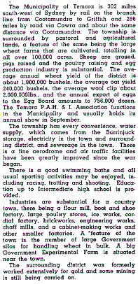
temora2.gif

In 1952 the Temora High School was opened and in 1971 a large pre-school premises was built. A reduction in secondary industry (the cordial factory closed in 1979) was partially relieved by tourism and the town’s historical society embarking on a rural museum in 1979. An extensive group of buildings was acquired, including Sir Donald Bradman’s original home. The township also contains several substantial buildings, a notable one being the Sacred Heart Catholic Church.

In 1969, on the property of harness-racing horse breeder, Colin Pike, a colt named Paleface Adios was born. The horse became the Pharlap of harness racing over an eight year career that ended in 1980. Temora has a memorial to “The Temora Tornado, Paleface Adios.” In 1981 the councils of Temora (town) and the surrounding Narraburra shire were united to from the Temora shire of 3,752 sq. km. The district’s gold mining past was revived when the Paragon open-cut gold mine was begun in 1987, about 12 km. north of Temora at Gidginbung. Temora has seven hotels and one hotel/motel. In 1994 the Temora shire had 120,494 ha. under pasture, 34,683 ha. growing wheat and 574,000 sheep and lambs.

Temora’s census populations have been 2,784 (1911), 3,823 (1931), 4,446 (1971) and 6,200 (1991 – enlarged shire). The town’s 1991 population was 4,279.

Further Reading:

  • Goffin, Graham, Paleface Adios, The Living Legend, Harness Racing Publications, 1982.
  • Temora Yesterday and Today 1880-1980, Temora Historical Society Inc., 1992.

Leeton

Leeton is a town and a shire in the Murrumbidgee Irrigation Area. It is 12 km. north of the Murrumbidgee River, 100 km. north-west of Wagga Wagga and 430 km. west of Sydney.

The town is relatively recent. In the early 1900s Hugh McKinney, an engineer with experience of irrigation works in the Indian Punjab, noted the similarity of the Riverina – Murrumbidgee plains to the Indian topography. In association with local pastoralists McKinney’s observation developed into an irrigation plan beginning with the Burrinjuck Dam (1906), on the Murrumbidgee River, south-west of Leeton.

The scheme was greatly assisted by Sir Samuel McCaughy, local pastoralist and member of the New South Wales Legislative Council, who had carried out irrigation works. He was the owner of North Yanco, the site of the future Leeton.

The Murrimbidgee Irrigation Areas Trust erected buildings at North Yanco in 1911. In 1912 the place was named Leeton after Charles Lee, Minister for public Works and a member of the Trust. The following year the Water Conservation and Irrigation Commission (successor to the Trust) added further buildings, including a School of Arts, as more workmen were engaged forirrigation works. It also commissioned Walter Burley Griffin to design thetown. Over 140 town allotments were sold on 2 April, 1913. Schools and churches were established from 1913 onwards, a hospital was completed in 1919, anda railway connection to the Narrandera line made in 1922. The commission established and operated numerous secondary undertakings including a stock sale yards, abattoirs, butter and bacon factories, a power house and canneries. Leeton was also noted for Co-operatives, including dairy farmers (1921),fruit growers (1932), cannery (1935), stock treatment (1937), poultry farmers(1943) and rice growers (1950).

Local government was vested in the Commission until 1921 when an Executive Board was appointed to assist. In 1928 the Willimbong shire was created,with Leeton as the administrative centre. The population of Leeton in 1933 was 3,629.

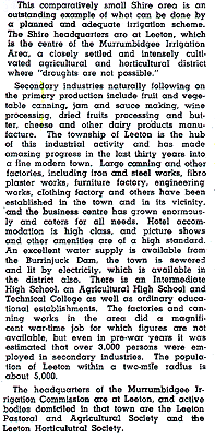
In 1949 The Australian Blue Book described Willimbong Shire (473 sq.km.) as –

leeton1.gif

By 1949 a substantial change had occurred in the social background of farmers. In 1924 61% of horticultural holdings in the Murrumbidgee Irrigation Area had been occupied by soldier settlers and 1% by Italians. In 1949 the figures were 18% and 32% respectively, and in 1972 Italians occupied 75%of holdings. The figure was lower in the Leeton (Yanco) area – 50% – but still a significant presence in the community.

Notwithstanding Leeton’s recent past, it has several buildings of note. The Historic Hydro, originally built for the Water Commission, is a motor inn and reception venue. There are 21 listed Art Deco buildings, including the Roxy Theatre. Leeton is the location of several educational services, including agricultural schools, a TAFE and the St. Francis De Sales Regional College. Sir Samuel McCaughy’s mansion is part of the Yanco Agricultural High School.

In 1993-4 crops in the Leeton Shire (1,132 sq. km.) comprised 11,562ha. of rice, 5,196 ha. of wheat, 2,330 ha. of orchards, 659 ha. vegetables and 474 ha. of vineyards. There were 142,000 sheep and lambs (mainly for meat) and 37,000 beef cattle. Manufacturing locations numbered 21, with a turnover of $373 million in 1991-2.

The census populations of Leeton have been –

Town/locality: 2,793 (1933), 5,148 (1954) and 6,245 (1991).

Shire: 8,992 (1947), 11,359 (1971) and 10,795 (1991).

Further Reading:

Yass

Yass, a town and a shire, is 294 km. south-west of Sydney and 75 km. west of Goulburn. It is on the Yass River, a tributary of the Murrumbidgee.

The Yass Plains were discovered in 1821 by a party which included Hamilton Hume. The name is thought to be derived from an Aboriginal word, yahr, meaning running water. Hume is buried in the Yass cemetery.

The plains were an attraction to settlers in the 1820s. Settlement of the Yass area was sufficient to warrant the establishment of a post office at Yass in 1835. A court of petty sessions was established there the following year and in 1837 the site for the Yass township was gazetted. The Yass district council was proclaimed on 14 August, 1843, and in 1848 the township had 55 houses and 274 people.

The district council was ineffectual, and the Yass municipality was proclaimed on 12 March, 1873. (Its boundaries extended some way into the surrounding farmlands, and in 1935 they were reduced to the township area.)

Sheep grazing and stud breeding provided the economic mainstay for Yass. The Ravensworth stud was founded in 1865, and was one of several which became famous for fine merino wool. The railway to Yass Junction, 5 km. out of Yass, was opened in 1877. It was a railhead for wheat and soft fruits aswell as wool by the 1880s. In 1878 the foundation stone for the Yass PublicSchool was laid and two years later a new court house was opened. It ison the Register of the National Estate. Several other grand government andbank buildings were built in the 1880s. A tramway connected Yass to YassJunction in 1892, the same time that the municipal gas supply was turnedon (The tramway closed in 1958.) In 1904 The Australian Handbook describedYass as –

yass1.gif

Shortly before the first world war the Burrinjuck Dam was constructedon the headwaters of the Murrumbidgee, about 30 km. south-west of Yass.It provided electric power to Yass. Like most rural towns the depressionand the second world war slowed development, but Yass was well positionedin the post war period to take advantage of the strong market for wool. In 1949 The Australian Blue Book commented that –

yass2.gif

Between 1946 and 1949 the Yass Council was in dispute with its itself and its town clerk but the local economy prospered with the sale of fine wool. Tourism was promoted with tourist roads, and the town underwent tree planting. The 1950s saw the construction of an Olympic swimming pool and a new high school. In 1966 the prime tourist attraction of Yass, Cooma Cottage,was purchased by the National Trust. The “cottage”, of 22 rooms,had been built in 1831 and lived in by Hamilton Hume for 33 years until1873. Tourism was augmented by recreational facilities on the Burrinjuck Dam.

On 1 January, 1980, the Yass municipality of 29 sq. km. was united withthe Goodradigbee shire and the new unit named Yass shire. Its area is 2987sq. km. The town has few manufacturing establishments, but accommodationestablishments had 700 beds in 1994. The pastoral hinterland of the shiregrazed 873,000 sheep and lambs, and 41,000 cattle.

Census populations have been 2,136 (1911), 3,662 (1954) and 8,780 (1991- enlarged municipality).

yass1.gif


Postcard undated, c. 1910.

Further Reading:

  • Bayley, William A., Yass Municipal Centenary History, Yass MunicipalCouncil, 1973.