Healesville

Healesville is a township 52 km. east-north-east of Melbourne, just south of the Watts River which is a tributary of the Yarra River. Upstream from where Healesville is situated gold was foundat New Chum Creek in about 1859. By 1860 New Chum was a village. However,it was the creation of tracks to the more distant Gippsland and Yarra Valley goldfields in the 1860s that resulted in a settlement forming at Healesville and its survey as a town in 1864. It was named after Richard Heales, Premier of Victoria, 1860-61.

The first land sale at Healesville was in 1865,and in the following year there were thirty business premises, includingsix hotels and a primary school. Healesville was also selected as a sitefor “neglected black and half-caste children and an asylum for infirm blacks.” Thus the Coranderrk reserve on Badger Creek, south of Healesville,was created in 1865.

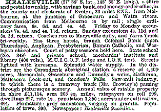
Healesville was situated on the most convenient coach route to the goldfieldsin the Woods Point area, and it was the place where fresh horses were takenfor the ascent to Fernshaw and Blacks Spur. In 1881 The Australian Handbookdescribed Healesville as –

healesville1.gif

As the Gippsland goldfields declined some miners took up farm occupations in Healesville. Timber cutters found employment, and hop gardens were established.In 1881 the railway had been opened between Hawthorn and Lilydale, 12 km.south-west of Healesville. Expectation of the railway’s extension to Healesville stimulated business and population growth. In 1889 the railway link was opened, two years after the Healesville shire had been created on 30 September,1887. The scenery of Fernshaw was more readily reached from the Healesville train terminus and tourism entered Healesville’s local economy. Gracedale House of 60 rooms was built in 1889.
sset1.gif

Farming developed in the newly cleared Don and New Chum Creek Valleys.Upstream on the Watts River the Maroondah Weir was built in 1891, the watershed requiring the removal of the Fernshaw township and curtailment of timber cutting. In 1893 the library and Mechanics’ Institute was opened. Despitethe limit put on timber cutting, Healesville’s economy grew – day outingsand travel to cool mountain retreats brought hundreds of people. The Australian Handbook’s description of Healesville in 1904 was –
healesville2.gif

Orchards and vegetable growing increased their acreages, along with a successful increased tobacco plantation. Elaborate country-retreat residences were built alongside hotels and guest houses, and a Tourist and Progress Association was created before 1914. In the 1920s the Association published “Healesville, The World-famed Tourist Resort”, listing over 40 beauty spots and 20 hotels and guest houses. The construction of the Maroondah Dam in 1927, replacing the weir, brought several hundred workmen to Healesville.Their departure, and the onset of the 1930s depression exposed Healesville’s restricted range of industries. Timber and tourism were not stable enough for sustained growth. Notwithstanding the depression, the 1930s saw increased motor tourism, partly bypassing Healesville, and decreased railway patronage.Only 10% came by rail in Easter, 1934. Tourism was still active but a local newspaper commented that Healesville would be “heaps better off callingitself the good-time town instead of the world-famed-tourist-resort – that’sgot whiskers on it.”

In 1934 the Sir Colin Mackenzie Sanctuary for Australian Fauna and Flora was opened on land that was formerly part of the Coranderrk reserve. The Healesville Sanctuary became one of Victoria’s premier tourist attractions.

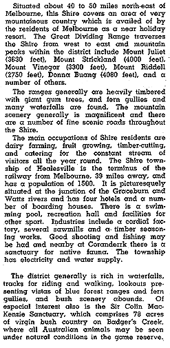
The outbreak of the second world war stimulated timber cutting, which initially concentrated on harvesting trees damaged in the extensive Black Friday bushfire of January, 1939. The early postwar years saw a resumption of traditional Healesville tourism, while petrol shortages lasted, but motortravel gradually made Healesville a wayside stop for many travelers. The Australian Blue Book described Healesville shire in 1949 as –
healesville3.gif

Forestry operations in he 1940s had increased Healesville’s population,and continued activity was required to sustain them. During the 1950s theshire unsuccessfully contested the Melbourne and Metropolitan Board of Worksview that the watersheds should be kept unlogged. Small industries makingfoundation garments, knitwear, electrical appliances and soft drinks contributedto a much needed diversification of employment activities. The Golf Houseguest house was taken over the for RACV Country Club in 1951. In January,1957, a new hospital was opened and in 1961 the central school (1952) wasreplaced by a high school. A new swimming pool was opened in 1964.

Healesville shire until the 1950s had undergone only minor boundary adjustments. However, the relatively close Yarra Glen had more in common with Healesville than with Eltham shire, and the Yarra Glen district wasadded to Healesville shire on 18 June, 1958. Northwards, Buxton went toAlexandra shire on 1 October, 1963. Healesville remained the larger commercialcentre in its shire, having 64 commercial establishment compared with 35in Yarra Glen in 1988.

The township has a comprehensive range of facilities. In addition tothe shopping centre there is a district hospital, Queens Park with a swimmingpool and sports facilities, a showgrounds and sporting complex, five churches,halls, Catholic school and State primary and high schools.

Healesville shire ceased on 15 December, 1994 when part was united withparts of Whittlesea city and Diamond Valley shire and most of Eltham shire to form Nillumbik shire. The other part was united with Alexandra and Yea shires and parts of Whittlesea city and Broadford, Euroa and Eltham shires to form Murrindindi shire on 18 November, 1994. At that time Healesville shire contained the localities of Badger Creek, Christmas Hills, Toolangiand Yarra Glen.

Healesville’s census populations have been 207 (1881),907 (1901), 2,035 (1933), 3,566 (1954) and 6,264 (1991).

Healesville shire’s census populations, after most of the significant boundary changes, were 5,941 (1961), 9,670 (1981) and 11,755 (1991). The urbanisation of Healesville shire was reflected in the median house price rising from 70% to 80% of the metropolitan average between 1981 and 1986.

Further Reading:

  • Symonds, Sally, “Healesville, History in the Hills”, PioneerDesign Studio, 1982.

Balwyn

Balwyn is a residential suburb 10 km. east of Melbourne. To its south are Canterbury and Surrey Hills and northwards are Balwyn North and Greythorn, which extend to the Koonung Koonung Creek.

Balwyn was part of Henry Elgar’s Special Survey of 8 square miles (1841), which was subdivided into small farms and grazing runs. One of the subdivisions was bought by a Scots editor and journalist, Andrew Murray (1813-80), in the late 1850s. He built a house which he named Balwyn, approximately on the site of the present Fintona Girls’ School in Balwyn Road. Murray planted a vineyard, and reputedly derived “Balwyn” from the Gaelic “bal” and the Saxon”wyn”. Other vineyards prospered until the 1890s, and grape vine branches formed part of Camberwell city’s crest. Balwyn was in the north of Camberwell city.

In 1868 the Balwyn primary school was opened in Balwyn Road, about 100 metres north of Whitehorse Road. It was moved tothe present site, south of Whitehorse Road, in 1880, opposite Murray’s property. Balwyn’s first town centre was near the intersection of Balwyn and WhitehorseRoads, containing a few shops, a blacksmith and the athenaeum or mechanics’institute. Anglican services began in 1868 and the St. Barnabas church, Balwyn Road, was opened in 1872. It is on the Register of the National Estate.

The southern part of Balwyn contains Deepdene,which in 1891 had a station on the Outer Circle railway running from Oakleighto Fairfield via Camberwell. The railway was built with land subdivisionsales in view, but its partial closure in a few years dampened prospects.A service continued from Camberwell to Deepdene until 1943, the last steamtrain service in metropolitan Melbourne, the “Deepdene Dasher”.Deepdene’s residential development awaited tramline extension in 1916 -northwards along Burke Road to Whitehorse Road and eastwards along WhitehorseRoad to Surrey Hills. Further to the north Balwyn had neither train nor tram, and a tram extension along Doncaster Road did not come until 1938.The terminus, however, was short of Balwyn’s easterly limit and the areas beyond the terminus (Balwyn North and Greythorn) awaited development inthe 1950s and 1960s.

Deepdene primary school was opened in 1915. TheCamberwell Grammar School, at the southern edge of Deepdene, occupies “Roystead”,which was a name given to one of the stations on the Outer Circle. Deepdeneh as an active strip shopping centre along the Whitehorse Road tramline,and further east Whitehorse Road shops are situated in Balwyn.

Balwyn’s strip shopping centre is larger than Deepdene’s,with a council library and community centre nearby. There are several reserves,one of them being Beckett park on an elevated site. Adjoining the park isthe Maranoa Garden, planted with a diverse collection of Australian flora.Oliver J. Gilpen’s mansion, subsequently Mary’s Mount convent and accommodationfor elderly persons, is near Maranoa Gardens.

Balwyn North, larger in area than Balwyn and Deepdenetogether, is predominantly postwar in its residential growth. In 1941 BalwynNorth was described as the next housing-site destination after the occupationof the Mont Albert Ridge in Balwyn was completed. The Doncaster Road ridge,Balwyn North, had a lovely view of the Yarra Valley and the Koonung Creekand in the opalescent distance, the sprawling city. Balwyn North was a mixtureof expensive suburban houses with beautiful gardens, and decayed dairy farmsand orchards, with tumbled down fences awaiting subdivision. The shops atBurke Road and Doncaster Roads are known as Dickens Corner, the site ofG.J. Coles and Coy’s first Supermarket (1961), which traded under the S.E.Dickens grocery banner. Neighbourhood reserves are fewer, but there arethree large ones with ovals and other facilities. There are three primaryschools (North Balwyn, Greythorn and Boroondara), and two high schools (Balwyn,years 7-10, Greythorn, years 11-12). The schools were opened between 1950and 1958. Greythorn named after Greythorn Road (so named because the firstproposed name, Whitethorn, was too like Whitehorse), is a locality withinthe larger Balwyn North. So too is Bellevue, near where Bulleen Road joinsthe Eastern Freeway as it skirts Balwyn North.

At the boundary between Balwyn and Balwyn North,the Yooralla Hospital for Crippled Children (Carlton) opened a branch at the corner of Belmore and Balwyn Roads. The locality is known as Yooralla, along with the few shops and a post office, although the school has altered in scope and is the Belmore Special School.

Between 1987 and 1996 the median house price in Balwyn was about 75% above the metropolitan median, and for Balwyn Northit was about 85% above the metropolitan median.

Further Reading:

  • Blainey, Geoffrey, “A History of Camberwell”,Lothian Publishing Company Pty. Ltd., 1980.
  • Maclean, Donald, “Balwyn 1841-1941”,Catherine Gregson, Melbourne, 1942.

Ivanhoe

Ivanhoe is a residential suburb 9 km. north-east of Melbourne, south of Heidelberg. The land occupied by Ivanhoe was one of several portions adjoining the Warringal (later Heidelberg) village surveyed in 1837. Sales occurred the following year and, the Ivanhoe portion was considered to be of unusual fertility and landscape appeal. It had Darebin Creek on the west and the Yarra River on the south. By the 1850s there was an Ivanhoe village, a name derived form Sir William Scott’s novel, and used from 1853. A school was opened in the Anglican church.

During the 1850s smaller farms were taken up and by the next decade there were two hotels, market gardens, orchards, an elementary racecourse and “gentlemen’s villas”. A state primary school which replaced the one in the Anglican church, was opened in 1881. The Australian Handbook, 1904, described Ivanhoe as –

This entry not yet available.

Between 1910 and 1930 Ivanhoe underwent residential development. From being a pretty township with handsome villas, a church school, a golf links and a population of 2,013 in 1913, it had 5,016 persons in 1921 and 7,701 persons in 1933. The Victorian Municipal Directory described it as –

ivanhoe1.gif

During the 1920s the Ivanhoe Girls’ Grammar School (1903) and the Boys’ Grammar School (1915) had growing enrollments. Another primary school in East Ivanhoe was opened in 1930. In 1937 the council offices of Heidelberg city were transferred from the old Heidelberg village to a new art deco civic centre in Upper Heidelberg Road, Ivanhoe. The move acknowledged that Ivanhoe’s shopping and commercial area was the more prominent of the two. Ivanhoe gained direct access to suburbs south of the Yarra River when the Burke Road Bridge was opened in 1926.

The areas of Ivanhoe which are distant from the railway station and shopping centre completed their residential development in the postwar years. Ivanhoe West, adjoining the Darebin Creek, has several Housing Commission dwellings and a small shopping area. The Bellfield primary school was opened in 1951. Ivanhoe East, adjoining the Yarra River, is famed for the Boulevard which overlooks the public golf course and Yarra Valley. Each Christmas residents decorate their houses and gardens and the display attracts many onlookers. There is an active strip shopping centre near the A.V. Jennings Beauview estate (1941). To the north is Eaglemont, which was developed during the prewar years, the attractions being its elevated position and proximity to a railway station.

Ivanhoe central has maintained its retailing dominance, with a combination of strip shopping and the Ivanhoe Plaza. There is a bowling club and tennis court near the shopping centre, and a croquet club, another bowling cub, tennis courts and ovals in parklands a little to the south nearer the river.

ivanhoe1.jpg


View of Ivanhoe from the clock tower of Heidelberg town hall in Ivanhoe, Heidelberg 1937

Heidelberg

Land at Heidelberg, 14 km north-east of Melbourne, was sold by Crown auction in 1838, making it one of the earliest rural allotments. (Central Melbourne’s first land sale was on 1 June, 1837). By 1840 there was a surveyed township named Warringal (Aboriginal for eagle’s nest). Warringal gave way to Heidelberg, a name applied by a land agent after the town in Germany.

Heidelberg was reached by a track from Melbourne via North Fitzroy, and in 1841 the Heidelberg Road Trust was formed. As a form of local government it preceded the Melbourne town council. By the late 1840s the road had a toll bar at the Merri Creek, and a macadamised surface. It became a tourist attraction, enhancing Heidelberg’s reputation as a desirable place for views, excursions and rural estates. Cattle overlander Joseph Howden had built his Gothic Banyule homestead in 1846 overlooking the Yarra Valley.

Heidelberg was made a shire on 27 January, 1871, and The Australian Handbook in 1875 described it as –

THIS ENTRY NOT YET AVAILABLE

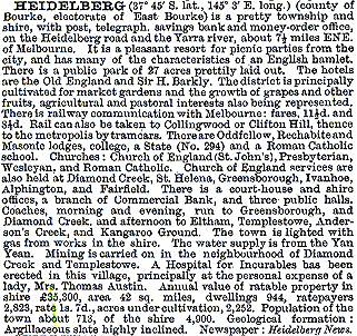
The village-like appeal of Heidelberg was repeated in the 1904 Handbook, and town amenities had grown –

heidelberg2.gif

Until the 1960s the Heidelberg municipality extended into Northcote on the west side of the Darebin Creek and northwards until 1964 when the semi-rural North Ward was severed and made the Shire of Diamond Valley.

heidelberg3.jpg


Heidelberg. 1937

Heidelberg had been proclaimed a City on 11 April, 1934, but its rural space exceeded the urban area. Subdivision and settlement clustered around Heidelberg Road and the Melbourne to Hurstbridge railway line which bisected the municipality in a generally north-east direction. Along that line are Darebin, Ivanhoe, Eaglemont, Heidelberg, Rosanna, Macleod, Watsonia and Greensborough. Mont Park was reached by a spur line from Macleod. Heidelberg West, unserved by railway, was sparsely settled until the 1950s when it was built on by the Housing Commission and provided the site for the athletes’ village for the 1956 Melbourne Olympic Games. In 1947 The Australian Blue Book described Heidelberg as –

heidelberg3.gif

The appealing rural scenery had attracted artists in the 1880s, not least because the absence of public utilities and a railway (until 1888) caused houses to be vacated and available at low rents. The plein air school of painting from Box Hill rented a cottage at Eaglemont in 1888, culminating in the “Heidelberg School” of Australian art. Two years later the Chartersville homestead was occupied for similar purposes. The views from Mount Eagle and across the Yarra Valley were especially impressive.

heidelberg1.jpg


The new Heidelberg town hall (Ivanhoe), Heidelberg 1937

By the 1970s the residential development of the Heidelberg municipality was complete but for some areas in Viewbank or Rosanna East. The shopping areas were mostly of the typical strip kind, but an early (1956) free-standing centre was built in Heidelberg West, to a design by the Housing Commission which drew on American trends.

The population of the Heidelberg municipality (before the severances in the 1960s) was 8,610 (1911), 34,401 (1947, excluding Greensborough), and 60,007 (1961). The population in 1991 was 60,468. On 15 December, 1994, most of Heidelberg City was united with part of Eltham Shire to form Banyule City.

heidelberg2.jpg


Contemporary homes, Mount Street, Heidelberg, Heidelberg 1937

Further Reading:

  • Garden, Donald S., “Heidelberg: The Land and its People 1838-1900”, Melbourne University Press, 1972.
  • “Heidelberg Since 1836: A Pictorial History”, Heidelberg Historical Society, 1971.
  • Topliss, Helen, “The Artists’ Campus: Plein Air Painting in Melbourne 1885-1898”, Monash University Gallery, 1984.