Port Melbourne, a residential and industrial suburb, is 4 km. south-west of Melbourne. It is bounded on its north and west by the Yarra River, on the south by Hobsons Bay and on the east Bay South Melbourne. The residential part adjoins South Melbourne.
In 1839, four years after the first permanent settlement of Melbourne, Wilbraham Liardet settled at Port Melbourne, building a hotel and jetty on Hobsons Bay and operating a mail service to Melbourne. The area became known as Liardet’s Beach, although the official district name was Sandridge. Land sales were delayed until 1850. The gold rush immigration brought passengers and freight which made use of a government pier on Hobsons Bay, served by Australia’s first railway line from Melbourne to Hobsons Bay.
The first allotments surveyed in Sandridge were between Stokes Street and a linear lagoon on the east, now Esplanade East. (The lagoon was probably an ancient course of the Yarra River.) With the railway, the township was enlarged, westwards to the railway line and northwards to Raglan Street.
A Wesleyan church was opened in 1853, and a Wesleyan school in the following year. By 1860 there were also Anglican, Catholic and Presbyterian churches, a Catholic school and a National school (1857). On 13 July, 1860, the Sandridge borough was created by severance from Melbourne City Council, its boundaries being the railway line and the lagoon, but further north to Bourndary Street. In addition to the Railway Pier there were the Sandridge Pier and the Town Pier at the end of Bay Street. The Swallow and Ariell Steam Biscuit manufactory was opened in Rouse Street in 1854, beginning with ships biscuits and expanding to become a major industry by 1880. Thomas Swallow was the Council’s second mayor and was influential in several of its community activities.
The borough remained confined between the railway line and the lagoon because of a planned canal between the Yarra River and the bay and the increasingly noxious condition of the lagoon, contributed to by the run-off from Emerald Hill, South Melbourne. Ideas to make the lagoon a dock did not materialsie, and it remained a harbour for small craft.
The coast west of the railway Pier was Sandridge Beach or Fishermens Bend, which was added to the borough in 1863. Its sand was extracted for Melbourne’s building trade, and in some cases the excavations were used as night-soil dumps. Bone mills, goats and pig-keeping added to the effluvia.
In the early 1860s the cream and red brick courthouse was constructed in Sandridge to a design by architect JJ Clark of the Public Works Department. After the first local election in 1861 the Council had met in the court house for the first time. It was also around this time that the police station and bluestone lock-up were built as part of the law enforcement complex. None of these buildings is still used for its original purpose.
In 1869 the first town hall was built in Bay Street. After congested accomodation in the church schools and the National school, a State primary school was opened in Nott Street in 1874. The Australian Handbook described Sandridge in 1875 as –
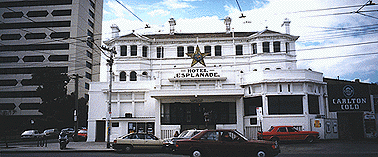
In 1884 Sandridge was renamed Port Melbourne. Its role as a transport centre meant that Port Melbourne was home to a number of hotels in the 19th century. The Fountain Inn (1860s), on the corner of Raglan/Crockford and Bay Street, was one such hotel. It remains largely intact today.
Port Melbourne also supported a number of industries during the 1800s. These included a soap and candle works, rice and flour mills, a sugar refinery, boot factory, chemical works, gasworks and a distillery.
In 1893 Port Melbourne became a town and on May 14 1919 was proclaimed a city.
In 1934-35 the cement rendered reinforced concrete beam and Centenary Bridge was constructed in Port Melbourne. Built as part of the Unemployment Relief Program of the Great Depression of the 1930s, the bridge features ornamented piers at its entrances. It was also the major publicly funded monument erected as part of Victoria’s Centenary Celebrations and was officially opened by the Duke of Gloucester. Centenary Bridge is today listed by the National Trust (Vic).
The suburb of Port Melbourne is located on Hobsons Bay, on the east bank of the mouth of the Yarra River, four kilometres south-west of Melbourne. It is today a part of the City of Port Phillip, which was formed by the amalgamation of the former cities of Port Melbourne, South Melbourne and St Kilda in 1994.
The port still plays host to cargo vessels and passenger ships, which dock at Station Pier (the northern section of which was built between 1922 and 1930). In modern times the suburb has also developed from one of Melbourne’s poorest areas into a wealthier residential area, blending more modern development with restored public buildings and workers cottages
The remaining text of this entry is not yet available. We apologise for any inconvenience caused.
Middle Park ,between the suburbs of Albert Park and St. Kilda, is 5 km. south of Melbourne. Its southern border is the Port Philip Bay and the northern border is the Albert Park parkland.
In 1857 a railway line was opened between Melbourne and St. Kilda, running along high ground to the south of the Albert Park Lagoon. There was also a linear lagoon on the other side of the railway, occupying about a quarter of the area of Middle Park. Most of Middle Park is not more than four metres above sea level.
In 1876 Canterbury Road, beside the railway line, was made and in 1879 the foreshore road was made and named Beaconsfield Parade. Low-lying areas were filled in. During the 1880s land was released for housing and the Middle Park railway station opened. Incomplete drainage systems caused subdividers to favour larger blocks than those in South Melbourne, foreshadowing the next century’s preference for quarter-acre sites. The Harold Street drain was of particular benefit.
By 1885 there were nearly 1,400 pupils at the neighbouring Albert Park primary school, and two years later a primary school was opened in Middle Park. By 1891 it had 600 pupils. In 1916 it became Melbourne’s first central school, continuing to year 8 until 1968. Notable pupils have included the Mott family (champion diver and champion swimmer), Justice Rae Else-Mitchell, Sue Calwell and Simon Crean.
In 1890 the Beaconsfield Parade promenade and the Middle Park baths were opened, boosting the area’s popularity with visitors who were already attracted to the Kerford Road pier. The pier, and Kerford Road, are on the register of the National Estate.
Most Middle Park churches are in Richardson Street: Baptist church (1904), Anglican church (1891), Presbyterian church (1912) and the Catholic church, most extensive of all, with a Carmelite Order, Kilbride College and Christian Brothers school.
Middle Park is a conservation area under the register of the National Estate, described as having mainly Edwardian dwellings, wide streets with mature trees and bluestone kerbs, and double storey shops in the area around the station. There are two fixed rail routes through Middle Park, along Danks Street near the foreshore (1925) and along the railway line, converted to light-rail tram in 1987. The shopping centre near the station is set off by the Middle Park hotel (1889).
Albert Park, a residential area with a large regional park and lake, is 3 km. south of Melbourne. It was named after Prince Albert, the Consort of Queen Victoria.
There are two Albert Parks, one the large recreational parkland and the other the adjoining residential area which spread southwards from South Melbourne’s Emerald Hill in the 1870s and 1880s.
The parkland was like much of the land in the Yarra delta, swampy, grassed with sparse tree cover, and with occasional lagoons, some quite large. The lagoon in Albert Park was one of those. The land was used for seasonal grazing, recreational hunting, rifle practice at the Butts (the original name of the Albert Park railway station) and for military training manoeuvres between the Victoria Barracks, St. Kilda Road, and the battery on Port Phillip Bay at the end of Kerford Road.
In 1857 a railway line was opened through Albert Park from Melbourne to St. Kilda. A short-lived rail loop from Windsor to St. Kilda (1859-62) passed through the south of the parkland. On 22 July, 1862, the parkland was temporarily reserved from sale, and permanently reserved two years later. In 1875 the land between St. Kilda and Queens Roads was severed from Albert Park and sold by the government as housing allotments. Between 1862 and 1875 Albert Park was reduced from 385 ha. to 231 ha., the loss being accounted for by the Queens Road severance and an earlier severance on the St. Kilda side.
The St. Kilda Cricket Club obtained permission to site its oval at the south end of the park in 1857 and the South Melbourne Cricket Club gained a permissive occupancy at the other end in 1862. The St. Kilda Bowling Club obtained its parkland site in 1865 and the Middle Park Bowling Club in 1903. A third cricket ground, now the Albert Cricket Ground, predated the Queens Road severance. Its neighbouring tennis courts (1889) became the site for major championships until the Lawn Tennis Association built the stadium at Kooyong. In 1908 the Davis Cup was played there.
Albert Park, 1997
In 1871 the Albert Park lagoons were used for boating, and the Albert Park Boat Club was formed the following year. Between 1873 and 1880 the lagoons were excavated to form the lake, and the excavated material used for land reclamation and embankments. The embankments were strengthened with timber piles and a promenade built. Municipal refuse tipping was also used for land reclamation, and dairy cattle grazed by agistment. Fresh water from the Yarra River was connected to the lake in 1890.
The suburb of Albert Park extends from the St. Vincent Gardens to Beaconsfield Parade and Kerford Road. It was settled residentially as an extension of Emerald Hill, South Melbourne. In 1854 a land-subdivision survey was done from Park Street, South Melbourne, to the northern edge of the parkland (Albert Road). St. Vincent Gardens were laid out and the surrounding streets became the best address for successful citizens. Street names commemorated Trafalgar and Crimean War personalities.
In 1874 the State primary school was opened, which within twelve years had 1,400 pupils. Its proximity to the beach encouraged swimming, and its 1905 squad included future champions, among whom was Frank Beaurepaire.
In 1903 The Australian Handbook described Albert Park as –
(The description includes the adjoining area of Middle Park.)
Albert Park developed a strong shopping strip along Bridport Street and Victoria Avenue, along which a cable-ram service had been opened in 1890. The tram also opened up the South Melbourne beach to people who lived further away.
During the prewar years some nibbles were taken out of the Albert Park. A precedent had been set in 1882 by the St. Kilda Park primary school (after much opposition), and the South Melbourne Technical School (1918) and the MacRobertson Girls’ High School (1935) were sited in Albert Park. The Army occupied large areas between 1941 and 1950, and in 1953 an Army officer proposed a racing Grand Prix in the park. Several races were held until stopped by the Government in 1958. The Army relinquished bits and pieces of space during the next twenty years.
Commercial uses such as the Carousel restaurant raised some money for park maintenance, but the end of Army rentals caused further financial stringency. Rents from South Melbourne and St. Kilda Football Clubs for their home grounds ended when they went elsewhere in 1982 and 1964.
During the early 1990s the lake was emptied to remove weed infestation, and Melbourne Water assumed management from the local committee of Management. On December, 1993, the State Government announced that the Australian Formula One Grand Prix motor race would be held in the park. Notwithstanding the protests by a Save Albert Park group the first race was held in 1996. The race circuit required trees to be cut down and facilities demolished, but funds were injected for replacement facilities.
Albert Park suburb has houses which are larger and built more of brick than weatherboard compared with South Melbourne. They have maintained their appeal to home buyers. In 1987 the median house price in Albert Park was 60% above the median for metropolitan Melbourne, and in 1996 80% above. The socioeconomic level is reflected by the outdoor cafes in Bridport Street. At the western edge of Albert Park the South Melbourne gas works was made into a park in 1982 with creative workshops and a gallery.
Dinghy Race on the Albert Park Lake.
Further Reading:
Barnard, Jill and Keating, Jenny, “People’s Playground: A History of the Albert Park”, Chandos Publishing, 1996.
Priestley, Susan, “South Melbourne: A History”, Melbourne University Press, 1995
St. Kilda is a residential suburb on Port Phillip Bay, 6 km. south-east of Melbourne.
During 1841-42 a cargo yacht “Lady of St. Kilda” was anchored in the bay, having been placed there for sale or barter. A colonial historian, Henry Gyles Turner, recorded that J.B. Were had an interest in the yacht and selected the raised sea side knoll at St. Kilda as the place for a picnic. The yacht’s captain was apparently present. From that event it appears that the place was named after the yacht. (The yacht’s name was presumably taken form the Hebridean island of St. Kilda.)
In December, 1842, allotments from a government survey were sold in the vicinity of Fitzroy Street and Lower Esplanade. Further lots were sold between 1846-51, by when St. Kilda was becoming an address of the well-to-do. The route to St. Kilda from Melbourne was a sandy track, commencing at a bridge (1846) over the Yarra River. The track was unsafe for travellers, and Strutt’s “Bushrangers” painting was reputedly inspired by an event on the St. Kilda road. An early hotel at St. Kilda, the Royal, was functioning by 1849.
Churches and schools began in St. Kilda in 1849, establishing a rich pattern of religious and educational institutions. The Anglicans held their first service in December, 1849, opened Christ Church and a school in 1851 and the present building in Acland Street in 1854; a second parish, All Saints, opened its church in Chapel Street in 1861. The Catholic church opened a church and school in 1853 in St. Kilda East. The Wesleyans held their first service in 1853 and built a church in Fitzroy Street (1857) which is on the Victorian Heritage Register. Presbyterians acquired a church in 1855 and the Free Presbyterians in 1864. Both churches built permanent buildings in Chapel Street.
In 1857 a railway line was built from Melbourne to St. Kilda, and a connection loop between St. Kilda and Windsor railway stations brought increased patronage to the privately run sea baths, the jetty promenade and the St. Kilda Cup was run at a racecourse near the Village Belle hotel. Cricket and bowling clubs were formed in 1855 and 1865. By the mid 1860s St. Kilda had about fifteen hotels including the George, formerly the Seaview (1857). St. Kilda by then was a borough (1863), having been proclaimed a municipality separate from Melbourne city on 24 April, 1855.
In 1870 Moritz Michaelis, a Jewish importer and merchant, built “Linden”, his residence at 26 Acland Street. The next year he and several other Jewish residents met to form the St. Kilda Hebrew Congregation. Michaelis laid the foundation stone for a synagogue in Charnwood Street. When Michaelis died at Linden in 1902, St. Kilda had a well-established Jewish community. The community has a land mark synagogue at the corner of St. Kilda and Toorak Roads and several religious and educational institutions extending eastwards to Elwood and Caulfield.
St. Kilda’s population more than doubled between 1870 and 1890 to about 19,000 persons. The opening of tram services to St. Kilda in 1888 and 1891 brought more pleasure seekers, somewhat lowering the tone and impelling the well-to-do towards South Yarra and Toorak. The 1890s depression caused several of the large mansions to be subdivided for apartment or boarding-house accommodation. “Oberwyl” was a spectacular example of a mansion built in 1856, whose owner failed in the 1870s, and the building became a school.
Wimpole’s Visitors’ Guide to Melbourne, Fredk. Wimpole, The George Hotel, 1881.
The pier and breakwater were constructed in sections between the late 1850s and 1884, adding to St. Kilda’s attraction. The Esplanade was landscaped and lit. In 1903 The Australian Handbook described St. Kilda as –
St. Kilda’s reputation for outdoors pleasure was enhanced by the formation of a council foreshore committee in 1906. It had the services of Carlo Catani an experienced engineer, who designed much of the foreshore reclamation and the Catani Gardens at the end of Fitzroy Street. The foreshore was hired out to open-air showmen, a forerunner to Luna Park (1912). St. Kilda’s mass-entertainment function was further broadened by the Palais de Danse (1913), which became a cinema two years later when a second dance venue was built.
St. Kilda changed from being a patrician village to a carnival – spectacular St. Kilda – according to its historian, J.B. Cooper (1930). However, its was not altogether a classless carnival, St. Kilda pier, the Esplanade and the St. Kilda Road boulevard provided an ideal entry point for vice regal and other visitors, such as Lord Brassey (1895), the Duke and Duchess of York (1901), Lord Jellicoe (1919), the Prince of Wales (1920) and the United States Pacific Squadron (1925). Cooper devoted two chapters to them. These events, however, became interludes during a trend to raffishness. Some of metropolitan Melbourne’s first flats were built amidst St. Kilda’s boarding houses and night-time entertainments were joined by brothels and street prostitution. The parks were a cheap substitute for rented rooms, and motor cars provided mobility. Melbourne City Council’s efforts to clean up Little Lonsdale Street in the 1930s forced women to work south of the Yarra. In 1932 St. Kilda’s V.C. hero, Albert Jacka, ex-Mayor, died, at a time when the depression was biting into the livelihoods of residents and local entertainers.
The depression, however, heightened the yearning for entertainment, and the Palais de Danse enjoyed strong attendances, as did the Palais Theatre (1927). In 1939 the St. Moritz ice-skating rink was opened in a former theatre which, between 1933 and 1935, had been the film studio for Frank Thring’s Efftee productions.
During the 1930s flat construction outnumbered house construction in St. Kilda by about ten to one. The growth in population density was high, and local shopping centres were enlarged.
The outbreak of war brought enlistments by local men and women, and the Pacific war brought American troops to Australian shores. St. Kilda’s entertainment precinct was a magnet for Australian and American services personnel. The artist Albert Tucker painted some memorable “Images of Modern Evil”, inspired by his observations of Australian good-time girls and soldiers on leave. On the other hand an illustrated pamphlet with verse composed round the popular tune “Thanks for the Memory” seemed to equally well capture the wartime relationships for many others.
During 1941-3 the Prest social survey conducted by the University of Melbourne confirmed that St. Kilda’s grand days had come upon mixed fortunes. Among the well off there were genteel poor, and lodgers and poor families were crowded into decayed residences.
The American invasion retreated as the Allied forces advanced on Japan. Another invasion in the postwar years was increasing cosmopolitanism, as immigrants journeyed to the beach for outings. Foreign menus were added to St. Kilda’s eateries. Candidates for Council election, however, became involved in clean-up campaigns, alarmed by deviant behaviour, crime, prostitution and drunkenness, but the council was unwilling to acknowledge that standards had slipped.
More flats were built during the 1960s, mostly privately financed, and some on under-sized sites. Entertainment such as Whiskey-a-Go-Go and Les Girls became metropolitan venues, and the Council was content to focus on these aspects rather than welfare needs or a municipal library. In the late 1960s, however, contesting views on sexual behaviour were played out as Bertram Wainer campaigned on abortion and Germaine Greer, who grew up in Elwood, published The Female Eunuch. The Council was forced to confront unconventional behaviour in its area in the 1970s as evidence increased about massage parlours, drug trafficking and street kids.
Palais Theatre, circa 1997.
Despite those things the Palais hosted the annual film festival, artists and galleries increased in the 1980s and the Astor theatre changed to less commercial art films after having been a Greek-film cinema. The council was contested by reform-minded councillors, and a library was opened in 1973.
The physical make-up of St. Kilda was change by increasing traffic from Brighton Road through the St. Kilda junction. In 1968 road widening works were begun and the road south to Carlisle Street widened by 1975, involving demolition of the Junction Hotel and 150 other buildings. In 1969 the St. Kilda marina was opened, following on from the Royal St. Kilda Yacht club, becoming the Royal Melbourne Yacht Squadron and taking over the St. Kilda baths which had been built in 1928.
The St. Kilda Football Club moved its home ground to Moorabbin in 1964, after having been at the Junction Oval since before its joining the League in 1897. The emotional loss was compensated for by the Cub’s first premiership in 1966.
During the 1980s and 1990s St. Kilda became better regarded for its polite cosmopolitanism. Kerbside cafes near Acland Street’s superb cake shops drew tourists, and Acland Street became a pedestrian mall. An art and craft market was opened on The Esplanade in 1969. St. Kilda’s natural attractions became evident to new residents in search of apartments and restored cottages. Between 1987 and 1996 the median house price in St. Kilda increased form 165% to 182% of the metropolitan median.
During the course of St. Kilda’s social change its schools and churches have maintained a strong presence. In 1990 the municipality had five government school campuses and fourteen non-government campuses. St. Michael’s Grammar School (1895, co-educational), had 1,300 pupils from kindergarten to year 12 in 1992.
St. Kilda has parks and gardens on the foreshore, in Albert Park and of Blessington Street either side of Acland Street. There are shops in Fitzroy Street and in St. Kilda Road south of the junction.
On 22 June, 1994, St. Kilda city was united with South Melbourne and Port Melbourne cities to from Port Phillip city.
The St. Kilda municipality had census populations of 6,408 (1861), 20,542 (1901), 38,579 (1921), 58,318 (1947), 61,203 (1971) and 45,481 (1991).
Luna Park from the Dinghy Jetty, St. Kilda. Postcard by Rose Stereograph Company.
Cake shop windows, Acland Street.
St Kilda scenes, circa 1997.
Further Reading:
Cooper, J.B., “The History of St. Kilda From Its First Settlement to a City and After, 1840 to 1930”, 2 vols., Printers Pty. Ltd., 1931.
Longmire, Anne, “St. Kilda: the show goes on: the history of St. Kilda, volume 3, 1930 to July 1983”, Hudson Publishing, 1989.
a "One Time Passcode" will be emailed to you to login