Metropolitan Farm, also known as Werribee Farm, is 35 km. south-west of Melbourne, between the western bank of the Werribee River and Corio. It borders Port Phillip Bay and has an area of 10,800 ha.
In 1892 the Melbourne and Metropolitan Board of Works established a sewerage filtration system on 3,580 ha. of land west of the Werribee River. The sewage was transported from the metropolitan area by a main which was assisted by a pumping station at Spotswood. The initial sewage-treatment process was the flooding of low-gradient land with untreated effluent, and its effectiveness was improved in 1926 with grass filtration, when evaporation is weakest during the winter months. A proportion of the land was available for livestock grazing.
Because of the area’s isolation employees were housed in a village which by 1910 had a post office and a population of about 300 persons. By the early 1920s there were three primary schools and a public hall. The schools were Cocoroc (1894), Cocoroc South and Cocoroc West.
Beef production became a profitable sideline, despite a scare about beef measles during the 1930s. Prize-winning bulls were produced on the Farm. Sheep grazing was usually done by bringing in flocks during the summer.
By the 1960s the availability of private transport increasingly enabled employees to live away from the Farm. The township was shut down by the early 1970s.
In addition to the land and grass filtration systems there are about 1,500 ha. of coastal lagoons for sewage purification. They have become a haven for birdlife and have been designated as a wetland of international importance by the International Union for the Conservation of Nature.
Metropolitan Farm’s census populations were 379 (1933), 477 (1947) and 129 (1966).
Further Reading:
Dingle, Tony and Rasmusden, Carolyn, Vital Connections: Melbourne and its Board of Works 1891-1991, Penguin Books Australia Ltd., 1991.
Little River is a rural township 44 km. west-south-west of Melbourne, on the train route to Geelong.
The Little River (shorter than the Werribee River to its east and the Moorabool River to its west), has headwaters in the Brisbane Ranges. It was also known as the Cocoroc Rivulet, Cocoroc being a locality near the area later occupied by Metropolitan Farm.
The road from Melbourne to Geelong crossed the Little River and the Travellers Rest Inn was opened there in about 1840. In 1852 a township named Rothwell was surveyed in the vicinity of the Inn, on the west side of the Little River. However, when the railway to Geelong was built the line crossed Little River about one kilometre north of Rothwell, and the railway station and goods shed (1857) were built on the other side of the river. A township developed near the station and the Rothwell survey fell by the wayside. (The railway station and goods shed, and the Rothwell Bridge built for the old Princes Highway in 1866, are on the Register of the National Estate).
An Independent Denominational school and St. Michaels Catholic school were opened in 1856 and 1858 respectively. By 1865 the township had three hotels and a mechanics institute. The surrounding land was good for grazing, with some dairying carried out. It had been one of the Port Phillip Association’s pastoral runs (the first occupier being James Simpson), and later a large part of the district was included in the Chirnside estate centred on Werribee. Small farmers had the benefit of an eight-thousand hectare common for grazing, and there were sufficient settlers for solid bluestone Anglican, Presbyterian and Independent churches to be built.
In 1903 The Australian Handbook described Little River as –
Little River remained virtually unchanged for several decades, known principally as an agricultural district on the way between Melbourne and Geelong, and as a resort for sportsmen. The substitution of the Princes Freeway for the Geelong Road took passing traffic further south of the village.
Little River has a few shops, a post office, a service station, three reserves, the mechanics institute, the primary school and its churches. A larger reserve exists where Rothwell was surveyed, and the Rothwell cemetery is further south. Little River’s census populations have been 4 (1861), 121 (1871), 294 (1911), 358 (1954) and 191 (1966). The estimated population in 1993 was 670.
Goods shed and railway station, Little River, 1997. J. Young.
Further Reading:
Wynd, Ian, “So Fine a Country: A history of the Shire of Corio”, Shire of Corio, 1981.
Altona is a residential and industrial suburb 13 km. west-south-west of Melbourne. The township is on an indented bay (Altona Bay) on Port Phillip Bay, and the industrial sector extends several kilometres inland. Altona’s southern boundary is Skeleton Creek (separating it from Werribee), and its opposite boundary is Kororoit Creek (separating it from Williamstown).
The coastal part of Altona is alluvial flats and recent estuarine deposits, with alluvial valleys extending inland along the Kororoit, Cherry and Laverton Creeks. The last two drained into swamps. Inland are newer basalt plains.
In 1842 (or probably before then), Alfred Langhorne leased pastoral land on Altona Bay, and shortly afterwards began building a homestead. The area was then known as Laverton. The homestead became known as “Altona” by the 1860s. The reason for the name is not clear, but in 1843 a neighbour of Langhorne’s, R. Wrede, gave his residential address as Altona, Port Phillip Bay. In any event Langhorne’s homestead acquired the name “Altona,” and it is in Queen Street, Altona, having served as a Council office and a community centre. “Altona” derives from a German village on the River Elbe, later a suburb of the Hamburg seaport.
Altona and Laverton were occupied for pastoral purposes. Prominent landowners were the Chirnside family, the Cherry family (hence Cherry lake), and the Blackshaws (hence Blackshaws Road). In 1881 a coal prospecting company was formed in Williamstown for the purpose of winning coal at Altona. Brown not black, coal was found and water penetration was a problem in the bores and tunnels. The activity, however, caused Altona to be noticed, for in 1882 a Sanitarium for infectious diseases was opened in Altona East.
In 1887 a syndicate acquired the Altona/Laverton property which had been assembled by Langhorne (who died in 1874), and marketed it as Altona. They commenced the connection of Yan Yean water, a railway extension from Newport and lengthening of the pier to deeper water for bay excursion boats. A nearby attraction was the Williamstown racecourse (now the Altona Sports Park). Land sales took place in 1888 and the train service commenced. Actual settlement at Altona, however, was meagre. The train service ceased in 1890, and Altona’s industrial potential was again assessed. Fresh coal mining ventures were started, and the colonial government established an explosive-storage depot near Skeleton Creek, Altona West, relieving a similar facility at Footscray. Proposals were examined for using the coal for the generation of electricity and for iron smelting. The Melbourne and Altona Coal Mine continued until 1919, and another one operated in the early 1930s.
Altona’s growth was slow, although enjoying moments of fame when early aeroplane flights were made by Gaston Cugnot (for the French Bleriot planes), and by Joseph Hammond in 1910 and 1911. Apart form coal mining the main industries were dairying, poultry, piggeries and the growing of animal fodder.
In 1913 a syndicate of Sydney entrepreneurs began replicating their success in developing beach-side suburbs by laying out generous subdivisions at Altona. The syndicate also established Seaholme, immediately to the east of Altona. Land sales began in 1917, and the railway recommenced. Two years earlier a primary school had been opened in Altona and Baptist church services begun. Residents obtained relatively cheap land on large blocks, and put up houses as owner-builders. During the first world war some families with German or other origins associated with enemy nations found it better to settle at Altona out of reach of patriotic workers at Newport. In 1920 land sales picked up, and houses were built with help from the War Service Homes Commission and the State Savings Bank.
In 1924 the Commonwealth Oil Refinery (C.O.R.) began production east of Seaholme. The refinery had mixed results: whilst providing local employment, the sulphur compounds in its effluent made the area smell. However, suburban comforts came to Altona with electrified trains, the promise of reticulated water and a shopping centre with a cinema. Subdivisions were released during 1928-9 at Altona North, Paisley and Galvin, the latter two being supplied with stations on the railway line to Geelong.
One suburban facility lacking in Altona was a hospital, until one was opened in 1932, financed by public subscriptions. It was kept during the depression by fund raising, donations of fish and eggs from local producers and by working bees.
During the second world war effluent entered Altona Bay from plant to the west. the I.C.I munitions factory at Deer Park.It poisoned the kelp, an important fish-breeding ground, and damaged Altona’s fishing and local amenity. Although the discharge was stopped, Altona’s seaside reputation was not enhanced during the war.
In 1949 Vacuum Oil began operating a refinery at Paisley, and in 1953 the Mobiltown railway station (Altona line) was opened to serve the refinery. Two years later a catalytic cracking plant increased production tenfold. There was a rapid growth in postwar population, and the Seaholme primary school opened a little earlier.
Altona was a destination for many postwar European migrants, and temporary and hostel accommodation was provided at the Williamstown racecourse and later on land on the other side of the Kororoit Creek at Wiltona Hostel.
Industries which opened in Altona included Gilbertsons/Don Smallgoods (1951), Red Robin hosiery (1949) and Australian Carbon Black (using refinery by-products for a component of tyre-making).
During all of its growth Altona was part of the Werribee shire. On 29 May, 1957, Altona was proclaimed a separate shire, and on 21 December, 1968, it was proclaimed a city.
The land at the Galvin railway station became the location of major petrochemical works in the late 1950s when Slough Estates purchased the large triangular wedge west of where the railway line crosses Kororoit Creek Road. The Altona Petrochemical Company’s plant came into production in 1961 and several others followed – synthetic rubber, several chemical plants and Union Carbide.
Two primary schools east and west of Altona’s town centre opened in 1961 and 1962, and a high school in 1960. The shire’s population grew by more than 50% between 1961 and 1966.
During the 1960s and 1970s Altona’s residents were troubled by air-borne particles and unpleasant chemical smells. Suspicion fell on petrochemical plants, although decaying seaweed might have been a cause. Air monitoring and political agitation reduced the incidents, and the closure of the Paisley briquette yard in 1972 removed an obvious cause. In the early 1970s sewerage connections were completed and reticulated water supply improved. The local hospital, a source of pride, was enlarged.
Altona township’s shopping centre in Pier Street has maintained its precedence. Drive-in shopping centres have been built further afield, in Altona North and Altona Meadows. During the 1980s the Pier Street shops were extended north of the railway line, unusual for a suburban strip.
North of the town the swamp area has become the Cherry Lake, surrounded by a conservation reserve and several sports facilities; to the east are a coastal park, yacht club and marina; and the western swamp area has water-treatment works and open-space reserves. At its extremity is the Kooringal Golf Club and a wetland which was previously the Cheetham Salt Works. Beach works during the 1980s stopped sand erosion. In 1985 the railway line was extended west of Altona to join the Geelong line at Laverton and the Westona station was opened.
The community has had a high proportion of residents from southern and eastern Europe, with a high proportion of religious adherents of both Catholic and Orthodox churches.
Altona had unusual municipal government, electing councillors by an unsubdivided municipality (i.e. no wards) and keeping them re-elected. Although in a Labor area, the Labor party gave up endorsing candidates when the voters’ preference for good local candidates was overwhelmingly obvious. The council staved off takeovers from Werribee and Williamstown councils in the 1980s. When the 1994 amalgamations happened, Altona city was united with Williamstown city and parts of Werribee shire and Footscray city to form Hobsons Bay city (22 June). By then the Altona municipality contained Altona Meadows, Altona North and the smaller localities of Paisley and Seaholme.
Between 1987 and 1996 the median house price in Altona was about 90% of the median for metropolitan Melbourne.
The census populations for the Altona township were 50 (1911), 694 (1921) and 2,841 (1947). For the Altona municipality they were 16,167 (1961), 25,020 (1966), 30,909 (1981) and 34,492 (1991).
Further Reading:
Priestley, Susan, “Altona: A Long View”, Hargren Publishing Company, 1988.
Werribee, about 27 km south-west of Melbourne, is midway on the Princes Highway to Geelong.It is situated on the Werribee River, which has its headwaters north of Ballan.
Early pastoral leaseholds included members of John Batman’s Port Phillip Association. Rural amalgamation began in the early 1850s, shortly after a village reserve was surveyed.
The village was named Wyndham, apparently at the suggestion of the owner of the new village inn, Elliott Armstrong, who knew Sir Henry Wyndham, a soldier who had distinguished himself at Waterloo. The name Werribee had already been given to the river, however, and overtook Wyndham as the town name (1884) and the shire name (1909). Werribee is though to be derived from an Aboriginal word for spine or backbone, which describes the strong visual curve of the river over the nearly treeless plain.
Rural amalgamation around Werribee was massive. Thomas Chirnside was attracted to the open plain’s suitability for grazing and its proximity to the Melbourne markets. By 1863 he controlled more than 28,300 ha. in the Werribee district. W.J.T. (“Big”) Clarke of Sunbury also had a substantial holding in the district. Pastoral dominance reducedthe number of smaller holdings as they were bought up by Chirnside in the1860s. The town grew relatively slowly, but steadily. A railway line wasopened between Newport and Geelong in 1857, with a station at Werribee.A Church of England school, opened in 1855, was replaced by a National schoolin 1861, the year in which a Catholic church was opened.
On 10 October, 1862, the Wyndham Road District was proclaimed, and wasreplaced by a shire council on 11 March, 1864. The shire extended from Footscrayto the Little River, and northwards to the Melton Reservoir. The area was276 square miles, or 715 square kilometres. It contained the places nowknown as Balliang, Exford, Hoppers Crossing, Laverton, Little River, Manor, Mambourin, Mount Cottrell, Tarneit, Truganina, Werribee South/Point Cook, and Wyndham Vale. The shire also included Altona until it was severed on 29 May, 1957, to form a separate shire. The name change to Werribee shire occurred on 15 December, 1909, and proclamation as a city took place on 20 March,1987. On 15 December, 1984 when Victorian council boundaries were restructured,the name was changed back to Wyndham, and a small part in the north was transferred to Melton shire.
Between 1860 and 1890 Werribee had two centres of gravity, the township and the Chirnsides’ Werribee Park. Thomas’ brother, Andrew, joined him in1875 in acquiring land around Werribee, ultimately enlarging the holding to over 37,600 ha. By 1878 the brothers had completed the building of theWerribee Park mansion, about three kilometres south of the Werribee township and 500 metres east of the Werribee River. The dry, rain-shadow property was augmented by wind-pump wells, and it became the site of coursing, hunt-clubs, elaborate annual picnics and a volunteer troops encampment for colonial defence. The Chirnside Battery’s drill ground was south-west of the mansionon a flat beside the river. In 1884 Thomas Chirnside donated land for St.Thomas’ Presbyterian church.
The suicide of Thomas, the Laird of Werribee Park, in 1887 and his brother’sdeath three years later resulted in the property being divided between Andrew’stwo sons. A second mansion “The Manor” was built by the son whoinherited the property north of the township.
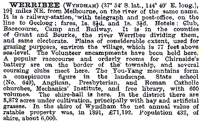
By 1881 about one-quarter of the shire’s population lived in Werribee township. Apart from hotels the principal recreational venues were the racecourse(1879) and the mechanics’ institute (1883). The Australian Handbook, 1893, described Werribee as –
Shortly after the Werribee Park estate came in the sons’ hands, land taxes persuaded them to bring in tenant farmers. The cleared grazing land was readily converted to cropping and dairying. During the early 1900s some tenant farmers became freeholders, and all told about 130 farmers were living on land that had recently been a family sheep walk. In 1892 the Melbourneand Metropolitan Board of Works acquired 3,580 ha. from the Chirnside estate for the metropolitan sewage farm, the site later being named Metropolitan Farm..
The Werribee township formed a progress association in 1910, to quicken the pace of change and improvement of amenities. Reticulated water was suppliedby the State Rivers and Water Supply Commission until 1929, when the YanYean supply finally connected.
In 1904 the State Government acquired land for closer-settlement farms,and the Commission’s irrigation improvements brought about successful settlement eight years later. It ushered in a community of Italian market gardeners,as well as orchardists and poulterers. The State Research Farm (now the Animal Research Institute) was begun in 1912. Soldier settlers took up farms after the first word war, and in 1925 the area was renamed Werribee South.
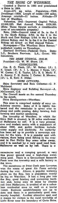
The Werribee Park mansion and 404 ha. of land was sold to the Catholic church, and became the Corpus Christi seminary for the training of priests.Some of the grounds were let to Italian farmers. Both the Chirnside sons left the district, moving to Brandon Park, Waverley,and to Chirnside Park. During the inter-war years the township’s population increased by about one-third, to a little more than 3,000 persons,sufficient to patronise a picture theatre (1928) and for the opening ofa higher elementary school 91923). Shortly after the second World War The Australian Blue Book, 1949, described Werribee shire as –
The township had four hotels, four churches, two savings banks and branches of two others, market yards and an agricultural and pastoral society. The cooperative milk factory was the only large industry that had been attracted.
Post war population growth was at first mostly in the eastern (Altona) end of the shire. Werribee township’s rapid growth began in the 1960s, thepopulation more than doubling between 1961 and 1971 to over 12,000 persons. The township acquired additional recreational facilities, new churches and denominational schools, two more State primary schools and a district hospital.I ts growth had been acknowledged by the construction of the Maltby By Pass, taking the Melbourne to Geelong road out of the town’s centre.
A new suburb adjoining the Melbourne side of Werribee, Hoppers Crossing,was commenced. It grew rapidly, acquiring a drive-in shopping centre in 1981, along with pre-school facilities and State and church primary schools.Four years after the Hoppers Crossing shopping centre the Werribee Plaza,about three times as big (39,000 sq. metres), was opened, but actually onthe edge of Hoppers Crossing. This left scope for the strip shopping centrenear the Werribee railway station to be enlarged and for a village shoppingcentre to be built on the other side of the railway line.
The Corpus Christi seminary closed in 1973 and the Werribee park property was sold to the State Government. The mansion and outbuildings have beencarefully preserved along with the formal gardens. A zoological park, theState Rose Garden and the State Equestrian Centre have been included inits grounds. The closure of the seminary did not herald the diminution ofthe Catholic community. The St. Andrews church had two active school campusesand a third one under consideration in the mid 1990s, and the McKillop secondarycollege was opened.
There is a linear park along the Werribee River, and elsewhere watercourses drain into swampy basins which are being made into recreationalwetlands. In addition to these large spaces there are ball-game courts andovals on two other reserves.
House prices in Werribee have been below the metropolitan median pricebetween 1987 and 1996, resting at about 80%. A survey of children on povertyin 1997 showed that 38% of Werribee children were in families on welfarebenefits or classed as working poor. It was not as well off as Altona (29%),but considerably better than the metropolis’ highest figure of 61% in Footscray.
The census populations of Werribee township andits immediate environs were 366 (1871), 693 (1901), 2,301 (1911), 3,348(1947) 8,228 (1966) and 12,872 (1971). The shire’s census populations were1476 (1871), 7853 (1933) and 16,114 (1954). Altona was severed in 1957 andthe new shire’s census populations were 13,689 (1961), 30,246 (1976) and72,230 (1991).
Further Reading:
Allom Lovell Sanderson Pty. Ltd., Werribee Park Metropolitan Park Conservation Analysis, 1985.
James, K. N. (ed.) Werribee: The First One Hundred Years, Werribee District Historical Society, 1985.
a "One Time Passcode" will be emailed to you to login