Bell Park is a residential suburb between Geelong North and Bell Post Hill. It was named after the Bell Park homestead, built by an early settler, John Bell. Part of the homestead is preserved in the buildings at the Grace McKellar Centre for Rehabilitation and Extended Care.
The residential settlement of Bell Park beganin the 1950s, and many of the new settlers were postwar European migrants. Two of the larger groups were Croatians and Italians. Many built make-do bungalows until they earned enough to build better finished dwellings. BellPark was made a separate Catholic Parish, and the Holy Family school and church are about central to Bell Park. Nearby is a Croatian community hall in a shopping area, along with the high school (1959) and the technicalschool (1968). They are now secondary colleges. There are also Greek Orthodox,Ukrainian (two), Russian Orthodox, Serbian Orthodox and Macedonian Orthodox churches.
There are two reserves with soccer fields adjoining the schools. A linearreserve runs along Bell Park’s northern boundary, Cowies Creek. At the southernend of Bell Park there are the Geelong Golf Club’s links and the Grace MaKellarCentre.
In 1987 and 1996 the median house prices in Bell Park were $53,000 and $84,000 respectively.
Further Reading:
Gibson, Norm, (ed.), “A Fresh Start in a New Land”, (oral history),Shire of Corio, 1988.
Wynd, Ian, “So Fine A County: A History of the Shire of Corio”,Shire of Corio, 1981.
Geelong, Victoria’s largest provincial urban region, is 65 km. from central Melbourne across the Port Phillip and Corio Bays. It is on the Princes Highway between Melbourne and Victoria’s Western District.
Hume and Hovell, explorers, recorded the Aboriginal word “jillong” in 1824, thought to mean land or cliffs, when they came to Corio Bay. The name “Geelong” was derived from the Aboriginal word, and was given to the area by Governor Bourke in 1837 when he visited Port Phillip and also formerly named Melbourne and Williamstown.
In June, 1835, John Batman crossed Bass Strait from Tasmania and claimed treaty lands from local Aborigines. The western boundary of Batman’s treaty land included Geelong.
Seventeen months later two of Geelong’s earliest settlers, John Cowie and David Stead, came from Tasmania to the Geelong district to depasture sheep. The Manifold brothers landed sheep at Point Henry two months later. Early in 1837 a pioneer Geelong citizen, Dr. Alexander Thomson, settled at the future Geelong suburb, Belmont, and established his Kardinia estate overlooking the Barwon River.
In 1838 the shipping activities caused a customs house to be erected. It has survived as probably Victoria’s oldest building – a round portable structure – and is in the Geelong Botanic Gardens. A town survey was made and land sales were conducted in February, 1839. The Woolpack Inn (later Mack’s) was opened in 1839 and the “Geelong Advertiser” began publication the following year. St. John’s Presbyterian church was opened in 1841. The sandbar blocking access past Point Henry was successfully passed over, and cargo movements were henceforth shared between Point Henry ad the Geelong waterfront.
During the late 1840s churches and schools were established and local industries such as flour mills, tallow works and vineyards were established. The Geelong town council was incorporated in October, 1849.
In the year before the gold discoveries at Ballarat and Bendigo the first Bright and Hitchcock’s store was opened. (It became a Geelong landmark until acquired by the Foy and Gibson’s chain in 1959.) The opening of the goldfields greatly increased Geelong’s maritime activity, not least because the inland route to Ballarat was flatter than the one from Melbourne over the Dividing Range. Outwards traffic also increased with wool from the Western District pastoral properties. The rapid growth also brought Geelong’s second major retailer, Morris Jacobs, whose store was also a landmark until acquired by Myer Melbourne in 1950. Geelong’s population went from 8,000 in 1851 to 22,000 in 1853. It thereupon stabilised, not reaching 30,000 for another sixty years.
During the late 1850s some of Geelong’s notable institutions and buildings were created: Geelong Grammar School and Geelong National Grammar School (later the Matthew Flinders Girls’ Grammar) in 1858, the Town Hall, Market Square, the mechanics’ institute, and the railway connection to Melbourne was opened. In the municipal sphere Geelong’s future was curtailed like Melbourne’s, with the creation of closely adjacent road districts and suburban councils – South Barwon and Bellarine/Indented Head roads districts, Newtown borough (1858) and Geelong West borough (1875). The resulting patchwork became the obvious first candidate for municipal reform in 1993.
In 1860 the Geelong football club won its first local premiership. The year after, one of the club’s notable players, Charles Brownlow, was born. His first year as a player was 1879, and he captained the team in 1884 and coached it from 1892 to 1917. He is commemorated with the Brownlow Medal for the competition’s best and fairest player. Geelong played a pivotal role in the growth of football, and was called the Pivotonians until the 1950s when the name was replaced by the Cats. (The Pivotonians came from Geelong’s rail and port role as a pivot for Western District Commerce.)
Geelong’s third notable educational institution, Geelong College, began in 1861. It was headmastered by the father of George (Chinese) Morrison.
During the late 1860s and the 1870s woollen mills, a meat preserving works and a brick and tile company were opened. The Barwon Paper Mill was opened near Fyansford in 1878, which was also the year when serious infestations of phylloxera were reported in the Geelong district’s extensive vineyards.
The Geelong mechanic’s institute fostered a technological school in 1869, which evolved to become the Gordon Technical College (1887) as a memorial to General Gordon of Khartoum. Extension of curricula led to it becoming the Gordon Institute of Technology (1921) and expansion to a campus at Waurn Ponds (1971), later Deakin University.
In 1894 a better seafaring lane across the sandbar was created with the Hopetoun Channel. Just before the formation of a harbour trust for the Geelong port, The Australian Handbook (1903) described Geelong –
Geelong town became a city on 8 December, 1910 and electric trams began running in 1912, but the first world war and the years immediately after it were a quiet period. Between 1922 and 1925 Geelong’s future industrial growth began: three woollen mills, Cresco fertilizers and the Ford Motor Company’s vehicle plant near Corio. The Corio whiskey distillery (1928) and the Geelong Advertiser’s radio station 3 GL (1930) were opened. In 1938 one of the last Port Phillip Bay steamers, Edina, (Edina?) made its final trip to Geelong, ending a romantic period of seaside excursions and contests for the fastest trip., On the eve of the second world war the International Harvester Works were opened beside Ford, and a grain-elevator terminal was built at Corio Quay.
In the postwar years Geelong entered a glorious period of growth. Successive football premierships (1951-2) were won and local cyclist Russell Mockridge, won two gold medals at the Helsinki Olympic Games. Population growth was rapid as postwar migrants settled in new suburbs. The Shell Oil Refinery opened at Corio in 1954, and the on-rush to modernity saw retail takeovers from Melbourne and the closure of the electric-tram services. The Alcoa aluminum refinery was opened at Geelong’s pioneering landing place, Point Henry, in 1963. Between 1947 and 1965 greater Geelong’s population went from 58,400 to 101,600 persons.
The rapid development beyond central Geelong resulted in small old industrial premises becoming under-used or abandoned. The mixed-use core of Geelong, with a network of lanes for access to small subdivisions and loading yards, became anachronistic. Urban consolidation for redevelopment overtook older areas, much like inner Melbourne underwent site consolidation during the 1960-80s. Market Square was developed in 1985, adding a department store, supermarket and 95 shops. Three years later in the adjoining block to the north Bay City Plaza was built with a department store, discount department store and 82 shops. The two sites added 45,200 square metres of retail floor space to Geelong, bringing it to over 160,000 square metres.
The Geelong city council boundaries extended from Rippleside at the western end of Corio Bay, along Western Beach and Eastern Beach and ended at Eastern Park, just beyond Limeburners Point. Eastern Beach with breakwater jetties and a swimming enclosure are the most notable amenities. Easter Park contains the Botanic Gardens, which have numerous rare exotic trees, sports facilities and the Geelong High School (1910). There are several foreshore reserves, smaller reserves, Johnstone Park beside the town hall and art gallery and Kardinia Park at Geelong South, home of the Geelong Football Club since 1940.
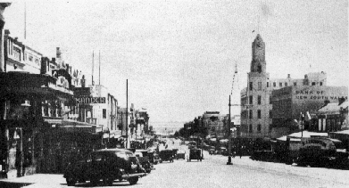
Geelong’s commercial and retail centre runs along the Moorabool Street spine of the town’s 1838 survey. The waterfront end contains several wool-export and commercial buildings which are suitable for refurbishment. The Dennys Lascelles warehouse (1872) Moorabool Street, became the National Wool Museum in 1987. The retail heart runs along the east-west little Malop Street pedestrian mall, adjoined by the redeveloped Market Square.
Immediately south of the commercial area there are three Catholic educational institutions and St. Mary of the Angels church, the Matthew Flinders Girls’ Secondary College, the Swanston Street primary school (1871-1993), the South Barwon Secondary College (formerly Geelong Technical School, 1913) and the Geelong Hospital (Kitchener memorial Hospital, rebuilt 1922).
Beyond these institutions is Geelong South, served by a railway station near the Kardinia Park football ground, Kardinia Park also has netball courts, a swimming centre and an elderly citizen’s club. There is a neighbourhood shopping area and a reserve beside the Barwon river. Further around the river there is the industrial area of Breakwater, which adjoins Geelong East. The Breakwater railway station is near the Geelong racecourse and showground (1907).
Eastern Beach and swimming pool (on Victorian Heritage Register). (Valentine photographic booklet, c.1947.)
Eastern Beach and swimming pool (on Victorian Heritage Register). (Valentine photographic booklet, c.1947.)
Over thirty buildings and structures in the former Geelong city are on the Victorian Heritage Register. Notable among them are seven warehouse/commercial buildings, Christ Church (1843), St. John’s Lutheran Church (1841) and the old post and telegraph offices, in addition to those previously mentioned.
The median house price in Geelong in 1987 was $62,250 and in 1996 it was $104,000.
On 18 May, 1993, the Geelong city (13.4 sq. km.) was united with Geelong West and Newtown cities, three shires and parts of two shires to form Greater Geelong city (1,252 sq. km.).
Geelong municipality’s census populations were 16,613 (1861), 9,721 (1881, Geelong West severed), 14,805 (1921), 20,034 (1954) and 13,036 (1991).
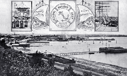
Western Beach and Corio Wharves, postcard, c.1909.
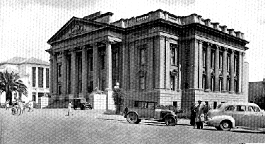
City Hall. (Valentine photographic booklet, c.1947.)
Further Reading:
Billot, C.P., “The life of Our Years: A Pictorial Chronology of Geelong”, Lothian Publishing Co., 1969.
Brownhill, Walter Randolph, “The History of Geelong and Corio Bay, 1955, With Postscript 1955-1990” by Ian Wynd, The Geelong Advertiser Pty. Ltd., 1990.
Willingham, Allan, “Geelong Region Historic Buildings and Objects Study”, Vol. 2, Geelong Regional Commission, 1986.
Little River is a rural township 44 km. west-south-west of Melbourne, on the train route to Geelong.
The Little River (shorter than the Werribee River to its east and the Moorabool River to its west), has headwaters in the Brisbane Ranges. It was also known as the Cocoroc Rivulet, Cocoroc being a locality near the area later occupied by Metropolitan Farm.
The road from Melbourne to Geelong crossed the Little River and the Travellers Rest Inn was opened there in about 1840. In 1852 a township named Rothwell was surveyed in the vicinity of the Inn, on the west side of the Little River. However, when the railway to Geelong was built the line crossed Little River about one kilometre north of Rothwell, and the railway station and goods shed (1857) were built on the other side of the river. A township developed near the station and the Rothwell survey fell by the wayside. (The railway station and goods shed, and the Rothwell Bridge built for the old Princes Highway in 1866, are on the Register of the National Estate).
An Independent Denominational school and St. Michaels Catholic school were opened in 1856 and 1858 respectively. By 1865 the township had three hotels and a mechanics institute. The surrounding land was good for grazing, with some dairying carried out. It had been one of the Port Phillip Association’s pastoral runs (the first occupier being James Simpson), and later a large part of the district was included in the Chirnside estate centred on Werribee. Small farmers had the benefit of an eight-thousand hectare common for grazing, and there were sufficient settlers for solid bluestone Anglican, Presbyterian and Independent churches to be built.
In 1903 The Australian Handbook described Little River as –
Little River remained virtually unchanged for several decades, known principally as an agricultural district on the way between Melbourne and Geelong, and as a resort for sportsmen. The substitution of the Princes Freeway for the Geelong Road took passing traffic further south of the village.
Little River has a few shops, a post office, a service station, three reserves, the mechanics institute, the primary school and its churches. A larger reserve exists where Rothwell was surveyed, and the Rothwell cemetery is further south. Little River’s census populations have been 4 (1861), 121 (1871), 294 (1911), 358 (1954) and 191 (1966). The estimated population in 1993 was 670.
Goods shed and railway station, Little River, 1997. J. Young.
Further Reading:
Wynd, Ian, “So Fine a Country: A history of the Shire of Corio”, Shire of Corio, 1981.
Queenscliff is a township at the entrance to Port Phillip Bay, named by Lt. Governor C. J. La Trobe after Queen Victoria in 1853. Before then the settlement had been called Whale Head and Shortland’s Bluff.
Queenscliff is connected by an isthmus to the Bellarine Peninsula on the west side of Port Phillip Bay. It overlooks The Rip, the entrance to the Bay. In the early 1840s a pilot service for ships was set up at Queenscliff. Lighthouses were erected at Shortland’s Bluff (the white lighthouse, 1862); at a point 300 metres north-north-east (the black lighthouse, 1861-2); and at Point Lonsdale (4.5 km. south-west). Ships fixing their position in relation to the first two lighthouses can navigate The Rip. Between those lighthouses was built Fort Queenscliff (1884-5) one of a defensive network of armed stations guarding the entrance to Port Phillip.
A local fishing industry was established quite early, having access to both the Bay and to Bass Strait. A telegraph station was built in 1856, and a municipal borough created in 1863. Its name is Queenscliffe, and includes the town of Point Lonsdale.
Around this time several other institutions began. A Queenscliff detachment of the Geelong Volunteer Artillery and rifle Corps was formed, the forerunner of the Fort. Presbyterian, Anglican, Catholic and Wesleyan churches were opened between 1862 and 1869. Four hotels and the large Foresters Hall were built by 1875. The railway was extended from Geelong in 1879, and during the next decade Queenscliff’s grand hotels were built. A gas works was opened in 1884.
By the turn of the century Queenscliff was a well established holiday resort, reached by railway of Bay steamer. The Australian Handbook, 1904, reflected Queenscliff’s importance –
Queenscliff’s importance for tourists and holiday-makers was eclipsed by motor-car access to other destinations in the inter-war and postwar years, but is had an extensive array of amenities. In 1940 the Victorian Municipal Directory’s description was –
A higher elementary school (1945) became a high school in 1957.
Despite the town’s infrastructure, modern motoring and motels caused a severe decline in Queenscliff’s prosperity. Maintenance standards and property values declined.
The tourism and civic infrastructure saw a revival in the 1980s, not least because of the grand hotel and civic architecture and the proximity to metropolitan Melbourne for day trips and weekends. Passenger and vehicular ferry services also connect to Sorrento on the east side of The Rip. Tourist attractions include the restored Bellarine Peninsula railway, between Drysdale and Queenscliff, the Vue Grand, Ozone and Queenscliff Hotels (making Queenscliff the culinary centre of the Bellarine Peninsula), and the wharves where fresh fish can be bought from the fishing co-operative. The shopping centre in Hesse Street is relatively large for the size of the community. Next to the wharves are the Marine Science Laboratories, and the remainder of the coast around the township is foreshore reserves with a pier and the Australian Staff College (formerly the Fort).
Bowling, tennis and netball facilities are in the town, and the golf course is reached by a bridge to Swan Island. In addition to the high school there are a primary school and a Catholic school in Queenscliff. Registered historic buildings include pilots’ cottages (1853), a lifeboat shed (1887) and the railway station (1881), but not the hotels. The median house price in 1987 was $88,500 and in 1996 it was $150,000.
Queenscliff’s census populations equated with those of the borough until Point Lonsdale grew during the early 1900s. Separate figures for each town have not been published. Census populations of the borough have been 954 (1871),2,000 (1891), 2,386 (1947) and 3,193 (1996). The 1991 census recorded that 26% of Queenscliff residents were 65 years or more, compared with 11% for Victoria.
The borough was unaltered by the 1994 local government amalgamations, a striking exception to the rest of Victoria.
Further Reading:
Bognuda, Joan and Moorhead, Leslie M., “Gateway to Port Phillip”, Jolbo Studio, 1980.
D.O.D., “Early Memories of Queenscliff”, 1931.
Dunn, N.A., “Borough of Queenscliffe 1863-1963”, Centenary Committee, 1963.
Loney, Jack,”Queenscliff Point Lonsdale (Tourist and Historical Guide)”, Marine History Publication, c.1980.
“Queenscliffe! How To See It, 1876-7, Facsimile”, Queenscliffe Historical Society, 1984.
Whillingham, Allan, “Geelong Region Historic Buildings and Objects Study”, Vol. 3, Geelong Regional Commission, 1986.
Aireys Inlet, a holiday resort on Bass Strait, is between Anglesea and Lorne and is 105 km. in a direct line south-west of Melbourne. It is reached by Geelong and the coastal Great Ocean Road.
The inlet receives river waters from iron bark forests of the Otway State Forest and from several streams which rise in the Angahook Forest Park.
In 1839 John Airey took up a pastoral run near Point Roadknight, east of the inlet. By 1842 his holding expanded along the coast beyond the inlet and was named the Angahook/Angohawk Run. It is probable that Aireys Inlet is named after him, although his brother George was a Commissioner for Crown Lands in the Geelong district, 1839-44.
In 1887 the relatively inaccessible inlet area was subdivided and about one hundred blocks were sold. A few were occupied. In 1890 the construction of a lighthouse was begun on the site known as Eagle’s Nest Point (renamed Split Point in 1913). The lighthouse, 100 metres above sea level, is made of cement-rendered concrete.
A school was opened in 1893, for children of families involved in Otways timber milling and of the few families at the inlet. The first school room was in a boarding house, and it continued until local timber milling declined after the first world war.
The Grand Hotel opened in 1894 and by 1903 there were also a post office and an Anglican church. Agricultural and pastoral activities supported the village. Access to Aireys Inlet, however, was by travel along the beach from Lorne at low tide or by road over the mountainous Otway Ranges. In 1905 a survey disclosed that a track along the edge of the coast was possible, and its construction was taken up as a project to employ returned soldiers. The Great Ocean Road Trust was formed and the road between Lorne and Anglesea was opened in 1922. (Completion of the road westwards to Apollo Bay took another ten years, which put Aireys Inlet on a coastal through-route.)
The opening of the Great Ocean Road ultimately produced a sufficient population for a school to be reopened in the 1930s, and for an Anglican church to opened in 1936. The population was borderline, though, and the school closed in 1942. It remained so until 1960 when classes were recommenced.
Aireys Inlet has a hotel, motel, caravan park and numerous flats and bed-and-breakfasts. The town centre does not have a large range of shops, as tourism depends on the coastal and bush-walking activities. The Angahook Lorne State Park (22,350 ha.) contains heath lands rich in orchids and ground plants, several types of eucalypt forest, meluleuca swamp and a fern gully. There are walking tracks on the lighthouse reserve.
During the early 1950s the Australian crime author, Arthur Upfield, lived at Aireys Inlet. His novel The New Shoe (1951) is based on the township and some of its characters drew on local identities. (The body was hidden in a cupboard in the lighthouse.)
West of Aireys Inlet, on the other side of the inlet, there are the surf beach and residential settlement of Fairhaven (1948) and the older settlement of Eastern View which had a guest house around 1910. The Eastern View subdivision estate was sold in the 1920s to raise money for the Great Ocean Road. Moggs Creek is nearby.
The median house price in Aireys Inlet in 1987 was $74,250 and in 1996 it was $140,000. The low figure in 1987 was three years after the Ash Wednesday fires which destroyed 219 houses in Aireys Inlet, 177 in Fairhaven, 87 in Moggs Creek and 32 in Eastern View. Dame Joan Hammond’s house at Aireys Inlet and her career’s memorabilia were destroyed. Although 83% of dwellings in 1976 were holiday homes, the proportion has fallen to less than two-thirds.
Aireys Inlet’s census populations have been 62 (1921), 93 (1961), 271 (1981) and 675 (1991).