
Bunbury, on Leschenault Inlet which flows into Koombanah Bay, is 185 km. south of Perth. Its elevation averages 4 metres above sea level.
The Port Leschenault area was inspected by a survey party sent there by Governor Stirling in 1830. A few settlers followed. In 1839 Lieut. Henry Bunbury found an overland route from Pinjarra (about midway between Perth and Bunbury) to Port Leschenault. Governor Stirling, arriving by sea, met Bunbury there and a town was notionally laid out and named after Henry Bunbury. Settlers arrived from 1838 onwards. The Anglican St. Mark’s Church was erected in 1842 at Picton (a Bunbury suburb), and is the oldest in Western Australia.
Bunbury remained a sparse settlement for the next thirty years. The speculative settlement at Australind, 7 km. north of Bunbury, had been abandoned at considerable cost to private investors in the 1840s.
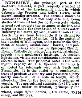
The census population in 1870 was about 300. Until the mid 1870s Bunbury’s destiny was dominated by a few influential families, but the extension of rating powers in 1878 to the Bunbury municipality (1871) effected a transfer of civic power. The Australian Handbook, 1875, described Bunbury as –
In the 1890s Bunbury achieved the infrastructure for its future role as a transport hub. A railway from Boyanup was opened in 1891 for the transport of timber. The railway connection to Perth was made in 1893. Timber mills and yards were opened near the jetty. Work was started on a breakwater in 1897. Coal from nearby Collie was transported through Bunbury.
Bunbury’s most famous son, Sir John Forrest, explorer and surveyor, was Western Australia’s first Premier. He was born in Bunbury in 1847 and relinquished the premiership when elected to the Federal Parliament in 1901.
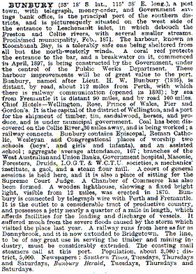
In 1904 The Australian Handbook described Bunbury as –
During the first world war a substantial dairy industry was established with a butter factory in Bunbury. Bunbury’s role as a wheat terminal was strengthened in 1937 by the construction of a silo near the port, ironically on the eve of a world slump in wheat prices. Fortunately, timber prices moved upwards, and the loss of overseas supplies with the outbreak of the second world war stimulated demand for Western Australian timber.
Until the post war years Bunbury’s transport role was not underpinned by links to local production. It would seem from the description in The Australian Blue Book of 1949 that the major local industry was tourism, which amounted to about 5,000 annual visitors –

The industrialisation of Bunbury in the 1950s included the mining of mineral sands, the opening of a chemical plant, bulk-fuel storage tanks and enlarged concrete wheat silos. The tensions between industrial development and environmental preservation came to a head in 1970 in the attempted detonation of a woodchip berth at the new Bunbury harbour. In 1994 exports through the Bunbury port were alumina (76%), mineral sands (12%), woodchips (11%) and other (1%).
Bunbury has a regional art gallery, an entertainment centre and several historic buildings. Its proximity to beaches and scenic landscape attracts tourism. There are twelve hotels, motels and guest houses with over 1,500 bed spaces. The municipality’s 61.2 sq. km. has a strong central business area, which contains 47% of all commercial floorspace. Retail floorspace in central Bunbury includes 74,000 sq. m. of retail use and 4,300 sq. m. of office/business floorspace.
Bunbury’s suburbs include Australind, Eaton and Geelorup.
Bunbury’s census populations have been 3,763 (1911), 5,140 (1933), 9,869 (1954), 17,779 (1971) and 25,657 (1991).
Further Reading:
- Barker, Anthony J. and Laurie, Maxine, “Excellent Connections: Bunbury 1836-1990”, City of Bunbury, 1992.
Related
-

The naming of the streets of Melbourne
Robert Hoddle, the surveyor who laid out the grid of early Melbourne, tells us in his journal how However Governor Bourke came to his tent one morning with names of the streets. Edmund Finn came to Melbourne in the early days of European settlement and worked as a journalist under the name of Garryowen. Here … Continue reading “The naming of the streets of Melbourne”
-

Princes Park Touch Summer 2023-24
In 2023-24 the tradition of “Social touch Football in Melbourne’s heart” continues with PPT’s Summer season.If you are interested in entering a team please visit the website, where you can find more information and the team entry process. https://princesparktouch.com Individual players should leave their details here.
-

We should all name and shame
In any society there has always been behaviour that is legal but undesirable. In the past this was discouraged by the close community bonds that existed that most valued and were fearful to jeopardise. Unfortunately those bonds are breaking down. My startup is working to remedy that by introducing functionality to “name and shame” individuals … Continue reading “We should all name and shame”

