
Leeton is a town and a shire in the Murrumbidgee Irrigation Area. It is 12 km. north of the Murrumbidgee River, 100 km. north-west of Wagga Wagga and 430 km. west of Sydney.
The town is relatively recent. In the early 1900s Hugh McKinney, an engineer with experience of irrigation works in the Indian Punjab, noted the similarity of the Riverina – Murrumbidgee plains to the Indian topography. In association with local pastoralists McKinney’s observation developed into an irrigation plan beginning with the Burrinjuck Dam (1906), on the Murrumbidgee River, south-west of Leeton.
The scheme was greatly assisted by Sir Samuel McCaughy, local pastoralist and member of the New South Wales Legislative Council, who had carried out irrigation works. He was the owner of North Yanco, the site of the future Leeton.
The Murrimbidgee Irrigation Areas Trust erected buildings at North Yanco in 1911. In 1912 the place was named Leeton after Charles Lee, Minister for public Works and a member of the Trust. The following year the Water Conservation and Irrigation Commission (successor to the Trust) added further buildings, including a School of Arts, as more workmen were engaged forirrigation works. It also commissioned Walter Burley Griffin to design thetown. Over 140 town allotments were sold on 2 April, 1913. Schools and churches were established from 1913 onwards, a hospital was completed in 1919, anda railway connection to the Narrandera line made in 1922. The commission established and operated numerous secondary undertakings including a stock sale yards, abattoirs, butter and bacon factories, a power house and canneries. Leeton was also noted for Co-operatives, including dairy farmers (1921),fruit growers (1932), cannery (1935), stock treatment (1937), poultry farmers(1943) and rice growers (1950).
Local government was vested in the Commission until 1921 when an Executive Board was appointed to assist. In 1928 the Willimbong shire was created,with Leeton as the administrative centre. The population of Leeton in 1933 was 3,629.
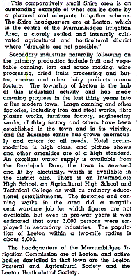
In 1949 The Australian Blue Book described Willimbong Shire (473 sq.km.) as –
By 1949 a substantial change had occurred in the social background of farmers. In 1924 61% of horticultural holdings in the Murrumbidgee Irrigation Area had been occupied by soldier settlers and 1% by Italians. In 1949 the figures were 18% and 32% respectively, and in 1972 Italians occupied 75%of holdings. The figure was lower in the Leeton (Yanco) area – 50% – but still a significant presence in the community.
Notwithstanding Leeton’s recent past, it has several buildings of note. The Historic Hydro, originally built for the Water Commission, is a motor inn and reception venue. There are 21 listed Art Deco buildings, including the Roxy Theatre. Leeton is the location of several educational services, including agricultural schools, a TAFE and the St. Francis De Sales Regional College. Sir Samuel McCaughy’s mansion is part of the Yanco Agricultural High School.
In 1993-4 crops in the Leeton Shire (1,132 sq. km.) comprised 11,562ha. of rice, 5,196 ha. of wheat, 2,330 ha. of orchards, 659 ha. vegetables and 474 ha. of vineyards. There were 142,000 sheep and lambs (mainly for meat) and 37,000 beef cattle. Manufacturing locations numbered 21, with a turnover of $373 million in 1991-2.
The census populations of Leeton have been –
Town/locality: 2,793 (1933), 5,148 (1954) and 6,245 (1991).
Shire: 8,992 (1947), 11,359 (1971) and 10,795 (1991).
Further Reading:
Related
-

The naming of the streets of Melbourne
Robert Hoddle, the surveyor who laid out the grid of early Melbourne, tells us in his journal how However Governor Bourke came to his tent one morning with names of the streets. Edmund Finn came to Melbourne in the early days of European settlement and worked as a journalist under the name of Garryowen. Here … Continue reading “The naming of the streets of Melbourne”
-

Princes Park Touch Winter 2o25
In 2025 the tradition of “Social touch Football in Melbourne’s heart” continues with PPT’s Winter touch rugby season.If you are interested in entering a team please visit the website, where you can find more information and the team entry process. https://princesparktouch.com Individual players should leave their details here.
-

We should all name and shame
In any society there has always been behaviour that is legal but undesirable. In the past this was discouraged by the close community bonds that existed that most valued and were fearful to jeopardise. Unfortunately those bonds are breaking down. My startup is working to remedy that by introducing functionality to “name and shame” individuals … Continue reading “We should all name and shame”

