
Kangaroo Island, of 4350 sq. km., is separated from the Yorke Peninsula by Investigator Strait. The larger, western end is administered by Kingscote District Council and the eastern end by Dudley District Council. They are joined by an isthmus.
Kangaroo Island figured in early maritime exploration. In 1802 Flinders went ashore from his vessel the Investigator and observed several brown kangaroos – hence the name. The French explorer Baudin was in the area at the same time, and a crewman left a carved inscription on a rock at Penneshaw, Dudley Peninsula.
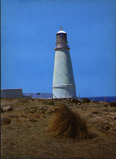
The western end of the island has lighthouses at Cape Borda (1850) and at Cape De Couedic (1906), facing ships crossing the Australian Bight. There is also a lighthouse at the eastern end at Cape Willoughby (1852).
In 1836 the South Australian Land Company established South Australia’s first white settlement at Reeves Point near Kingscote. Paucity of soil and water caused most settlers to withdraw, but stone ruins can still be found in the area which is now an historic reserve.
Fertile land was found in patches, particularly Cygnet River, and early farming was supplemented by eucalyptus oil distilling and the harvesting of pith from Xanthorea trees for explosives. Soil improvement was successfully tried in the 1920s – 30s, and extensive clearing and pastoral expansion followed, mainly for soldier settlement in the early 1950s around Parndana. The island has special controls against pests and exotic weeds, and breeds pure Italian bees for overseas apiarists. In the 1980s a depressed wool market led to production of ewes’ milk and yoghurt. In 1992-3 livestock numbers were 920,000 sheep and 11,000 cattle. Live and net fishing, and crayfish and prawn fishing are carried on.
The principal towns are American River, Kingscote, Penneshaw, Parndana, and Emu Bay.
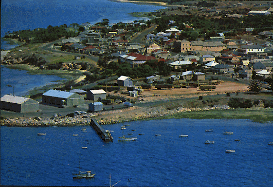
Aerial View of Kingscote, c.1980 (Souvenirs Australia Pty.Ltd.)
Tourism is a significant element in the local economy, and is the most important industry in American River where it was started in 1895. There are daily ferry services between Adelaide and Kingscote and from Cape Jervis to Penneshaw, as well as an aerodrome. About 30% of Kangaroo Island is National Parks, the principal one being Flinders Chase at the western end. there are several coastal parks, with features such as Seal Bay, Kelly Hill Caves and Remarkable Rocks.
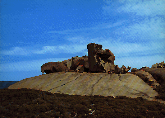
Remarkable Rocks, c.1980.
In 1993 the island ran over 1.1 million head of sheep and lambs and 11,000 beef cattle.
The census populations of Kangaroo Island have been 1,341 (1911), 1,479 (1947), 3,515 (1981) and 3,902 (1991).
Further Reading:
- Kangaroo Island Tourist Assoc., Kangaroo Island, 1989.
- Kingscote Country Women’s Assoc., Kangaroo Island: Past and Present, c. 1950.
- Leigh, W.H., Travels and Adventures in South Australia 1836 – 1838, facsimile, The Currawong Press, 1982.
- Masterman, Mervinia, Flinders Chase, Flinders Chase Revisited, n.d.
- Tyler, M.J. et al, Natural History of Kangaroo Island, Royal Society of South Australia, 1979.
Related
-

The naming of the streets of Melbourne
Robert Hoddle, the surveyor who laid out the grid of early Melbourne, tells us in his journal how However Governor Bourke came to his tent one morning with names of the streets. Edmund Finn came to Melbourne in the early days of European settlement and worked as a journalist under the name of Garryowen. Here … Continue reading “The naming of the streets of Melbourne”
-

Princes Park Touch Winter 2o25
In 2025 the tradition of “Social touch Football in Melbourne’s heart” continues with PPT’s Winter touch rugby season.If you are interested in entering a team please visit the website, where you can find more information and the team entry process. https://princesparktouch.com Individual players should leave their details here.
-

We should all name and shame
In any society there has always been behaviour that is legal but undesirable. In the past this was discouraged by the close community bonds that existed that most valued and were fearful to jeopardise. Unfortunately those bonds are breaking down. My startup is working to remedy that by introducing functionality to “name and shame” individuals … Continue reading “We should all name and shame”

