
Wodonga is a provincial city in north-east Victoria, bordered by Albury on the other side of the Murray River. It was named after the Wodonga pastoral run, taken
up by Paul Huon in 1836, although it was his brother Charles who became the district’s pioneer.
Immediately north of Wodonga are the Wodonga river flats, through which passes the flood-prone Murray River. At the point where the Wodonga Creek and the Sydney road intersected with the Murray River, a town was surveyed by the Victorian government surveyor in 1852. It was named Belvoir, after Charles Huon’s homestead. The formation of other official townships along the Sydney road in the next few years marked the road as the main inter-colonial truck route, and Belvoir’s position immediately before the river crossing made it a stopping-off place. During the 1860s Belvoir became known as Wodonga (thought to be an Aboriginal word meaning bulrushes), and a gazettal on 7 August, 1874, confirmed the change of name.
By 1865 Belvoir had a school (1857), a court of petty sessions, branches of insurance offices, two hotels, a flour mill, and a saw mill. The estimated population was 500 persons.
During the 1870s Wodonga’s population increased rapidly: pastoral runs were opened for selection and the railway from Melbourne to Wodonga was opened in 1873. Wodonga shire was created on 10 March, 1876, its area including Bandiana and Bonegilla to the south-east of Wodonga. Its area was 167 square kilometres. The first causeway across the Wodonga flats was formed in 1870, becoming the forerunner of the Lincoln Causeway on which the Hume Highway was built. In 1890 a branch railway line to Tallangatta, east of Wodonga, was opened.
The animal saleyard at Wodonga had large throughputs of meat and dairy cattle and, when the Victorian border tax reduced sales, horses for the Indian Army were bred locally and sold through Wodonga. Dairying along the river flats was active and the Wodonga Butter Factory was amalgamated with others to become the North-Eastern Dairy Company.
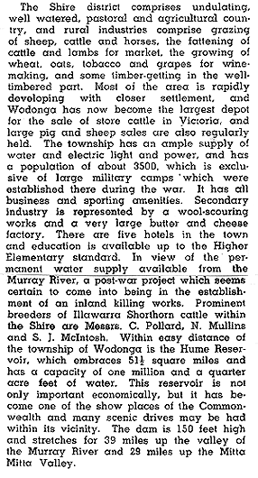
In 1903 The Australian Handbook described Wodonga –
 |
In 1919 the River Murray Commission began construction of the Hume Dam upstream of Wodonga, about twelve kilometres eastwards. Starting at a time when settlement of an irrigated Murray Valley would make it a “land fit for heroes”, the project was completed in 1936 towards the end of the depression. During the course of the project the temporary Ebden Weir township housed up to 500 workers and their families, and its site is marked by a memorial erected in 1924, the centenary of Hume and Hovell’s southern exploration. (Ebden was named after Charles Ebden, pastoralist.)
During the second world war military camps were established east of Wodonga at Bandiana and Bonegilla. Bonegilla was used for training infantry, and bomb-disposal personnel. It later became a migrant reception centre, and many immigrants settled in Wodonga in the immediate postwar years. Postwar industries were established in clothing, timber milling and pipe-making. The shire’s populations more than doubled between 1947 and 1954. In 1949 it was described in The Australian Blue Book –
 |
Further industries were opened in Wodonga, notably Uncle Ben’s pet food (1967). In 1973 the Commonwealth, New South Wales and Victorian Governments agreed to the Albury-Wodonga Development Scheme, for a decentralised growth area. Although the growth fell short of projections, Wodonga municipality’s population doubled between 1971 and 1991 to 26,389. Wodonga is the minor partner to Albury, having 30% of Albury-Wodonga’s office space (1986) and about the same proportion of retail floor space.
During 1954-63 two primary schools, a high school and a technical school were opened. Wodonga West primary school was for children from Housing Commission estates and from married quarters at the Bandiana military camp. Since then two more primary schools, a secondary college, the Clyde Cameron Trade Union College and a LaTrobe University Campus have been opened.
Wodonga has a racecourse, recreation reserve and showgrounds near the Bandiana military camp, a large livestock saleyards, several parks along watercourses, sports ovals, a golf course, an indoor sports and leisure centre and a wide range of other community services. The town and residential area were bypassed in 1985 by an extension of the Hume Freeway, joined to the Lincoln Causeway.
Wodonga had eleven hotels and motels in 1997, providing 668 bed spaces. The median house price in Wodonga in 1987 was $74,000 and 1996 it was $108,750. Wodonga’s farm activity is grazing, with 100,000 cattle and 16,900 sheep and lambs in 1994.
In 1996 the median weekly personal income of residents aged 15 years or more was $300, which was $29 higher than the median for the Ovens-Murray region.
Wodonga’s census populations have been 254 (1861), 909 (1901), 3,066 (1947) and 7,789 (1961). After then the published population figures have been for Albury-Wodonga. The municipality’s census populations have been 1,568 (1881), 3,250 (1933), 10,924 (1954), 18,087 (1981) and 29,188 (1996).
Further Reading:
- Albury-Wodonga Future Directions Final Report July, 1990, Albury-Wodonga
Region Planning Committee, 1990. - Dunlop, Alan J., Wodonga Over River and Plain, Hawthorn Press,
1976. - Joes, Howard C., Wodonga City: a Jubilee History, Wodonga Rural
City Council, 1998. - Martin, Desmond, A Tale of Twin Cities: Part 1 – The Founding Years,
Graphic Books, 1981.
Related
-

The naming of the streets of Melbourne
Robert Hoddle, the surveyor who laid out the grid of early Melbourne, tells us in his journal how However Governor Bourke came to his tent one morning with names of the streets. Edmund Finn came to Melbourne in the early days of European settlement and worked as a journalist under the name of Garryowen. Here … Continue reading “The naming of the streets of Melbourne”
-

Princes Park Touch Winter 2o25
In 2025 the tradition of “Social touch Football in Melbourne’s heart” continues with PPT’s Winter touch rugby season.If you are interested in entering a team please visit the website, where you can find more information and the team entry process. https://princesparktouch.com Individual players should leave their details here.
-

We should all name and shame
In any society there has always been behaviour that is legal but undesirable. In the past this was discouraged by the close community bonds that existed that most valued and were fearful to jeopardise. Unfortunately those bonds are breaking down. My startup is working to remedy that by introducing functionality to “name and shame” individuals … Continue reading “We should all name and shame”

