Gembrook

Gembrook is 54 km. east-south-east of Melbourne and 18 km. east of Belgrave. It was the terminus of a narrow gauge railway from Belgrave, now the “Puffing Billy” scenic railway.

Gembrook was first settled in 1873 for farming and timber getting. The country was suitable for dairying and orchards. Timber clearing provided income while farms were brought into production. The name came from small emeralds and sapphires found by early settlers in a nearby watercourse.

In 1878 a combined Anglican/Presbyterian church was built in Gembrook and a school was opened the following year. The general store was built in about 1880. The carriage of timber and produce from Gembrook was usually southwards to a railway station on the Gippsland line, but the roads were often boggy. Throughout the 1890s the Victorian Railways considered rail access to Gembrook from several directions, ultimately deciding on a narrow gauge connection from Belgrave. It was opened on 18 December, 1900. The railway brought urban excursionists and stimulated timber mill activity,. About twenty mills operated in the surrounding forest, with tramlines to the Gembrook rail terminus. A hotel was built in about 1901.

The railway also transported potatoes to the metropolitan market, and potato growing became a major industry. The volcanic soils produced good yields which were topped up by increasing applications of superphosphate. Subsequent applications of dieldrin pesticides for potato crops have rendered some properties unsuitable for grazing of beef cattle.

A bushfire in 1926 burnt out many timber mills. The 1939 Black Friday fires were less severe, but the Gembrook Fire Brigade was formed the following year. North of Gembrook is the Gilwell Park Scout Camp (1927).

By the time the railway closed on 30 April, 1954 (following a landslide which blocked the line), motor traffic had replaced much of the railway’s patronage. The re-opening of the western end of the line as a scenic railway occurred in 1962, and a short section from Gembrook was re-opened in the early 1990s. A monthly market is held at the Gembrook railway station. The township is small, having a few shops, churches, a school, a community centre, a hotel and a sports ground.

The census populations of Gembrook have been 506 (1911), 609 (1954) and 745 (1991).

General Store, Gembrook, c.1918.

Further Reading:

  • Parker, Genseric, “Forest to Farming, Gembrook: an early history”, J.D.P. Consultancy, 1995.

Gladstone Park

Gladstone Park is the eastern part of Tullamarine, 15 km. north of Melbourne. It has the Moonee Ponds Creek to its north and east. The name comes from a grazing property owned by Thomas Gladstone between 1869 and 1883.

The area was subdivided for farms in 1842, and the Gladstone Park property was the best-watered and the only one to be sold. It was farmed until sold in 1887 to a land speculator, but his speculation was unsuccessful and the property returned to the Gladstone family. It continued to be farmed until coming into the hands of the Gladstone Park Syndicate in 1954. The Syndicate was part of Stanley Korman’s Standhill conglomerate.

Stanhill produced an elaborate subdivision plan but met with financial difficulties. The Commonwealth Government’s credit squeeze in 1961 caused the company to default and Costain and A.V. Jennings became the joint developer/builder of Gladstone Park. In 1966 they began the ten-year project of building 3,000 houses in Gladstone Park. In 1970 the area’s first primary school was opened.

Gladstone Park has a street configuration which is designed to discourage through traffic in most residential streets. There is a second State primary school, a State secondary college and a Catholic school. Gladstone Park drive-in shopping centre has nearly 19,000 sq. metres of gross lettable area, and five neighbourhood reserves are distributed towards the edges of the residential area. Part of the skirting Moonee Ponds valley, however, is the site of the Western Ring Road which was constructed during the mid 1990s.

The median house price in Gladstone Park in 1987 was the same as the Melbourne metropolitan median price and in 1996 it was 94% of the metropolitan median.

Further Reading:

  • Lemon, Andrew, “Broadmeadows: A Forgotten History”, City of Broadmeadows and Hargren Publishing Company, 1982.

Kangaroo Island

Kangaroo Island, of 4350 sq. km., is separated from the Yorke Peninsula by Investigator Strait. The larger, western end is administered by Kingscote District Council and the eastern end by Dudley District Council. They are joined by an isthmus.

Kangaroo Island figured in early maritime exploration. In 1802 Flinders went ashore from his vessel the Investigator and observed several brown kangaroos – hence the name. The French explorer Baudin was in the area at the same time, and a crewman left a carved inscription on a rock at Penneshaw, Dudley Peninsula.

The western end of the island has lighthouses at Cape Borda (1850) and at Cape De Couedic (1906), facing ships crossing the Australian Bight. There is also a lighthouse at the eastern end at Cape Willoughby (1852).

In 1836 the South Australian Land Company established South Australia’s first white settlement at Reeves Point near Kingscote. Paucity of soil and water caused most settlers to withdraw, but stone ruins can still be found in the area which is now an historic reserve.

Fertile land was found in patches, particularly Cygnet River, and early farming was supplemented by eucalyptus oil distilling and the harvesting of pith from Xanthorea trees for explosives. Soil improvement was successfully tried in the 1920s – 30s, and extensive clearing and pastoral expansion followed, mainly for soldier settlement in the early 1950s around Parndana. The island has special controls against pests and exotic weeds, and breeds pure Italian bees for overseas apiarists. In the 1980s a depressed wool market led to production of ewes’ milk and yoghurt. In 1992-3 livestock numbers were 920,000 sheep and 11,000 cattle. Live and net fishing, and crayfish and prawn fishing are carried on.

The principal towns are American River, Kingscote, Penneshaw, Parndana, and Emu Bay.

kanga1.gif


Aerial View of Kingscote, c.1980 (Souvenirs Australia Pty.Ltd.)

Tourism is a significant element in the local economy, and is the most important industry in American River where it was started in 1895. There are daily ferry services between Adelaide and Kingscote and from Cape Jervis to Penneshaw, as well as an aerodrome. About 30% of Kangaroo Island is National Parks, the principal one being Flinders Chase at the western end. there are several coastal parks, with features such as Seal Bay, Kelly Hill Caves and Remarkable Rocks.

kanga2.gif


Remarkable Rocks, c.1980.

In 1993 the island ran over 1.1 million head of sheep and lambs and 11,000 beef cattle.

The census populations of Kangaroo Island have been 1,341 (1911), 1,479 (1947), 3,515 (1981) and 3,902 (1991).

kanga3.gif

Further Reading:

  • Kangaroo Island Tourist Assoc., Kangaroo Island, 1989.
  • Kingscote Country Women’s Assoc., Kangaroo Island: Past and Present, c. 1950.
  • Leigh, W.H., Travels and Adventures in South Australia 1836 – 1838, facsimile, The Currawong Press, 1982.
  • Masterman, Mervinia, Flinders Chase, Flinders Chase Revisited, n.d.
  • Tyler, M.J. et al, Natural History of Kangaroo Island, Royal Society of South Australia, 1979.

Carnarvon

Carnarvon is a town and a shire about 900 km north of Perth, situated near the mouth of the Gascoyne River. It is named after the Earl of Carnarvon, Secretary of State for Colonies, 1866-1874.

The Carnarvon area was first explored by George Grey in 1839, the Gascoyne attracting his attention as a possible opening to an inland sea. Grey reported favourably on the country for grazing and agricultural purposes. In 1858 Francis Gregory explored the hinterland, giving a cautious report on its potential. Settlement was left until 1876, and in about 1880 a hotel was built on the site of Carnarvon. In 1883 the town site was surveyed, and connected by telegraph to Perth the following year, strengthening Carnarvon’s port function by giving it timely information on market conditions.

In 1887 the Jubilee Hall was erected as a memorial to Queen Victoria’s Jubilee celebrations, housing the library and municipal chambers until 1973 and 1965 respectively.

The town’s white population was 226 when Carnarvon was made a municipality in May, 1891.

Carnarvon was described in 1904 in The Australian Handbook as –

… a municipality at the mouth of the Gascoyne river, on the north-west coast, 489 nautical miles from Fremantle. It promises to become an important settlement, and is the shipping port of the various sheep stations established in the district. It was proclaimed a municipality on May 19, 1891. Steam and sailing vessels call regularly, and good fresh water is obtainable. There are two good jetties. It contains three hotels, a post and telegraph office, money-order office and savings bank, branch of Union Bank, school, residency, Anglican church, library, custom house, courts house, gaol, hospital and four stores. Water service to all houses. Chiefly pastoral district. Population, about 318.

The district’s grazing capacity was acknowledged with the construction of a meatworks in 1920. The sinking of bores had yielded prolific water flows since the early 1900s, and the growing of bananas and tropical produce was started in the early 1920s. Many farmers were European immigrants. (Much of the Gascoyne River percolates through the sand and settles on a hard sandstone bed.) The establishment of banana and vegetable growing in the 1930s halted Carnarvon’s population decline.

In 1921 an air service between Geraldton and Carnarvon was established. In 1935 the Gascoyne River bridge was opened, spanning the sand beds which experience seasonal floods. In 1915, after flooding had threatened to wash away the township, a protective bank made of bundles of sticks was built., The bundles were like those on the Italian fascist badge, used for strengthening military trenches, and the area is today known as the Fascine.

The immediate post war period saw a rapid increase in agricultural output – vegetables for Perth and farms settled by ex-servicemen. In 1949 The Australian Blue Book described Carnarvon as –

… served by a weekly shipping service and a bi-weekly ‘plane service. The ‘plane links with Perth, via Geraldton, returning on alternate days.

As a port, Carnarvon exports large quantities of wool, sheepskins, kangaroo skins and livestock yearly, and is the main shipping point for the large Gascoyne district. In an average year over 29,000 bales of wool and 93,000 sheep are handled from this port. This is in addition to large numbers of stock, which are overlanded to southern markets.

A new industry which has been established is tropical fruit growing, particularly bananas, which are grown, mainly, on the banks of the Gascoyne River. It is estimated that the capital value of properties engaged in this production is some £50,000, employing between 150 and 200 persons on 60 properties. The winter climate of Carnarvon is delightful, and as the town has some splendid hotel accommodation available, it attracts a considerable flow of visitors. It is reticulated with water and electric light, while the majority of buildings are modern.

The Municipality of Carnarvon is the only town of note in this section of the country, and, in addition to its port activities, is the business centre for practically the whole of the vast area covered by the Gascoyne-Minilya, Shark Bay and Upper Gascoyne Road Boards.

The offices of the Gascoyne-Minilya Road Board are located in Carnarvon.,/p>

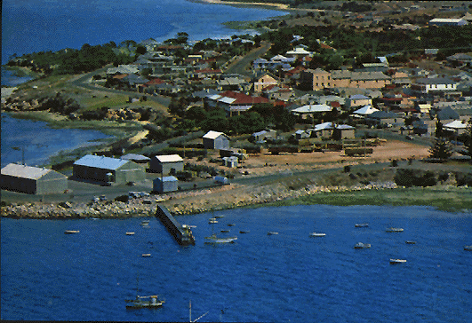
A whaling station operated on Babbage Island, near Carnarvon, from 1950 – 1962. It was later replaced with a prawning factory. The island was the site of the port jetty, one mile long, built in 1904. It was served by a tramway to bring passengers and goods to Carnarvon. State shipping transport improved, and the jetty was closed to the public in 1994.

During the 1960s Carnarvon became the site for the American National Aeronautical and Space Administration and for international radio and communications operated by Radio Australia had the Overseas Telecommunications Commission. The tracking station is on a sacred Aboriginal site. A salt and potash mine was established in 1969, employing up to 300 workers.

Carnarvon experiences severe cyclones. The Jubilee Hall lost its roof in 1960, a year coinciding with bad floods. The banana plantations have been damaged several times. Nevertheless, Carnarvon grows 80% of the bananas and 15% of the vegetables produced in Western Australia. The paving of the highway to Perth in the 1960s cut travel time by 75%, helping the marketing of perishables.

In 1990 a new civic centre and art gallery were built on the site of the former railway goods shed. The Shire of Carnarvon occupies 53,000 sq. km., including 300 km. of coast line. Coastal attractions include fishing, blowholes 73 km. north of Carnarvon and a memorial to HMAS Sydney, the scene of Australia’s greatest wartime loss of life. The wreck of the German raider, Kormoran, which sunk the Sydney lies on the shoreline. Further north is the Coral Bay town and resort on the Ningaloo Reef.

Carnarvon’s municipal census populations have been 727 (1911), 2,239 (1954) and 9,046 (1991).

Further Reading:

  • Larman, Jessie, Carnarvon, “Artlook”, c.1983.
  • Memory, R.Scott, “A Town Grows: Carnarvon”, Western Australia, 1967.
  • Visitor’s Guide, “Carnarvon”, Carnarvon Tourist Bureau, c.1995.
  • Wilson, H.H., “Cyclone Coasts: Australia’s North-West Frontiers”, Rigby Publishers Ltd., 1980.

Caboolture

Caboolture, 46 km. north of Brisbane, is a township and shire.

The area was not officially settled until 1842, as before then any settlement within fifty miles of the Moreton Bay penal establishment was unlawful. The name came from that of an early local pastoral station, which was derived from the Aboriginal word cabultja, meaning carpet snake. Transformation to a more defined locality occurred after the discovery of gold at Gympie in 1867, some 100 km. northwards. Cobb and Co. coaches to Gympie and Maryborough used Caboolture as a stopping-off-point. The predominantly farming community was described in The Australian Handbook, 1875, as –

caboolture1.gif

In 1879 Caboolture was made into a municipal area, and in 1888 it was connected to Brisbane by railway. (The municipality’s boundaries included the areas of Redcliffe and Pine Rivers, which have since been severed.) Caboolture’s proximity to provincial and metropolitan markets encouraged food production, especially dairying. The Handbook’s description of Caboolture in 1904 was –

caboolture2.gif

In 1947 the shire’s population was 3,074 and the town’s 1,400. By the 1970s Caboolture’s rural spaces were being taken by residential expansion from metropolitan Brisbane. The towns of Burpengary and Morayfield, situated on the Bruce Highway like Caboolture, and part of the shire underwent residential settlement. In 1971 the shire’s population was 12,207, in 1986 it was 44,783 and five years later it had increased by 53% to 68,447. The estimated population in 1994 was 90, 772.

caboolture3.gif

Caboolture is positioned almost centrally in its shire of 1,232 sq. km. Westwards the shire includes Woodford. Eastwards there are Toorbul, Donnybrook and Beachmere, and a short distance across the Pumicestone Passage is Bribie Island. The southern half of the island is under Caboolture shire’s jurisdiction. Deception Bay is at the south of the shire.

In 1993 Caboolture’s shrinking rural hinterland had 8,600 dairy cattle, 7,200 meat cattle and 10,300 pigs. There were 647 business locations involved in agriculture, fishing and forestry in the shire in 1994. Construction had 394 business locations, retail 370 and property and business services 230 in 1994.

Caboolture’s central business district is situated on the north side of the Caboolture River, adjacent to the railway station. Adjoining the river are a large recreation area with sports grounds and facilities and nearby are a botanic gardens and sanctuary. The Historical Society has created an historical village with over 60 buildings.

Further Reading:

  • “The History of Caboolture and Districts”, Caboolture Historical Society, 1988.

Gawler

Gawler, about 40 km north of Adelaide, was proposed as a place of settlement by Colonel William Light in 1837 when travelling through the area with members of the South Australian Company. While the company did not act on the proposal, a number of other settlers applied for a Special Survey of 1618 ha. A town – 40 ha. commercial and 60 ha. public and civic – was surveyed in 1839, and named after the Governor of South Australia, George Gawler. Only Adelaide and Port Adelaide preceded Gawler.

Gawler is situated on the junction of the North Para, South Para and Gawler Rivers, and the Barrier and Sturt Highways converge at Gawler.

The discovery of copper at Kapunda caused the movement of goods between there and Adelaide. Gawler became a stopping place. Traffic grew more when copper was discovered at Burra in 1846. Local government by a district council came in 1854, and Gawler was separately incorporated as a town on 9th July, 1857. The district’s agricultural expansion was stimulated by the growth of mining. The railway from Adelaide reached Gawler in 1857 and was extended to Kapunda in 1869. In the 1870s small farms became available for selection, and Gawler’s industrial infrastructure was added to: flour mills (1845-64), foundries (1860s-1875) and chaff-cutting (1879). Adjoining suburban townships were surveyed. Until the turn of the century Gawler enjoyed high prosperity, a keystone being contracts for railway rolling stock. Water from the Barossa Water Scheme was reticulated in 1901. The 1904 edition of The Australian Handbook described Gawler as –

gawler1.gif

The first three decades of the twentieth century brought mixed results to Gawler. The building industry stimulated sand quarrying – bringing transport, employment and licence fees to the local Council. But work for the foundries lessened, and strikes increased. By 1929 unemployment was rising. Economic independence waned, more of the workforce found employment outside Gawler, and the town began its transformation to a dormitory suburb. However, enlargement of the town resulted in re-unification of the town and district councils on 22nd June, 1933. The post-war period brought more urban settlers, attracted by lower land prices. In 1949 The Australian Blue Book described Gawler as –

gawler3.gif

Post-war suburban growth included developments by the South Australian Housing Trust and the influx of new populations. The focus of community and cultural activities on the Gawler Institute shifted to Government-funded schools and institutions; long-standing shops and businesses were overtaken by metropolitan firms.

By the 1970s Gawler emerged as a major regional centre, with both residential and commercial growth. The municipal boundaries of 1933 were enlarged by taking parts from three surrounding district councils on 13th March, 1985. Gawler’s suburbs comprise Gawler West, South Evanston, Evanston Gardens and Evanston Heights (southwards and westwards) and Willaston (eastwards).

The 1970s also saw considerable redevelopment of the old town centre, with an emphasis on conservation. A four mill which closed in 1970 was converted to offices. Several other historic buildings are preserved. Although Gawler is relatively close to Adelaide its position on the route to the Barossa Valley enables it to include tourism in its local economy.

Further Reading:

  • Phillips, Susan and Pickington, Michael, “Gawler’s Industrial Buildings 1839-1939”, University of Adelaide, Department of Architecture, 1980.
  • Treloar, Wendy; “History of Gawler The first 50 years

Tea Tree Gully

Tea Tree Gully is the name of a municipal council of 96 square km. and of a relatively small township. They are north east of Adelaide, the township 15 km. The area was first settled in 1837, and two years later land was surveyed and sold as farms for cereals, orchards and pasture.

Tea Tree Gully was originally called Steventon, John Stevens being a prominent landholder. However, the gully was a notable one, as it provided a gradient negotiable by bullock wagons travelling through the Mt. Lofty Ranges and it had permanent springs which promoted the growth of tea tree. The area was part of the Highercombe district council, and Tea Tree Gully became the name of a smaller Council in October, 1858, when Highercombe was split in two. When the two district councils were re-united in May, 1935, the new Council was named Tea Tree Gully.

The locality was entirely rural during the nineteenth century and well into the twentieth century. Extractive industries and viticulture predominated. The Australian Handbook’s description in 1904 was –

teatree1.gif

The census records through to the 1950s signify Tea Tree Gully district council’s rural environment – 1,014 (1911) and 2,561 (1954). As late as 1970 numerous vineyards remained around Tea Tree Gully township, and some of their names such as Modbury and St. Agnes have been given to later residential suburbs. Residential subdivisions grew apace from the late 1950s, and the Tea Tree Gully Plaza Shopping Centre was opened in 1970. Two years before, on 8th February, 1968, the municipality had been proclaimed a city. By the mid 1980s residential subdivision was well advanced. Twenty suburbs are situated in the council’s boundaries, including from south to north – Hope Valley, Highbury, Modbury, St. Agnes, Banksia Park, Modbury, Ridgehaven, Redwood Park, Wynn Vale, Yatala Vale, Fiarview Park and Golden Grove. Golden Grove is a recent residential area, a planned housing estate jointly developed by the private sector and the South Australian Land Commission.

In 1975 a new public library was opened next to the civic centre, and two Council recreation centres were opened in 1976. Tea Tree Gully’s access to central Adelaide was improved with the O-Bahn Busway in 1986.

Some of Tea Tree Gully’s hospital’s and schools in their short time since the 1960s have experienced peak usage for new-born and youth populations followed by declining usage for those purposes by the 1990s. Some older suburbs have experienced a population decline – Banksia Park and Tea Tree Gully – 12% , 1986-1991. The dormitory nature of Tea Tree Gully has been accompanied by the provision of recreational facilities, walking trails and playgrounds. The number of playgrounds is high, along with local parks and reserves. About two-thirds of the municipality is residential and in 1991 90% of houses were detached. Eighty-four percent of all houses were owned or were being purchased by the occupiers. All these figures exceeded the averages for metropolitan Adelaide. Secondary and extractive industries are zoned away from residential areas.

The census populations of Tea Tree Gully have been 1,014 (1911), 2,561 (1954), 5,887 (1961), 21,314 (1966), 36,708 (1971) 67,237 (1981) and 85,969 (1991).

Further Reading:

  • Auhl, Ian, From Settlement to City: A History of the District of Tea Tree Gully, 1836 – 1976, 1976 – 1993, Tea Tree Gully Council, 1993.
  • Taylor, Robyn, From Settlement to City: Tea Tree Gully 1976-1993, Golden Grove 1970-1993, Tea Tree Gully Council, 1992.

Wagga Wagga

wagga_logo.gif

In December 1829, the early colonists first sighted the land on which the flourishing City of Wagga Wagga now stands. The persons thus privileged consisted of Captain Charles Sturt, 39th Regiment, stationed in Sydney, Mr George Macleay and six others. This party passed over the site of future Wagga Wagga on its expedition of discovery down the Murrumbidgee and Murray Rivers. Settlement swiftly followed.

Wagga Wagga was proclaimed a town in 1849 and in the same year surveyor Thomas Townshend marked out the town. In the 1860s the population totaled approximately 700, but by 1881 it had increased to 3,975. In 1879 the railway line was extended south of the river.

The name of the City is derived from the language of the Wiradjuri tribe, which was the biggest aboriginal tribe in New South Wales, embracing the Riverina area.

“Wagga”, “Wahga” or Wahgam” in aboriginal dialect means “crow”. The repetition of a word was the method of expressing the plural or emphasis, thus Wagga Wagga means “crows” or “the place where crows assemble in large numbers”. The Murrumbidgee River which runs through the City also derived its name from the aboriginal language and means “plenty water” or “big water”.

Wagga Wagga is 518km by rail from Sydney and 432km from Melbourne on the main Southern line. It is 185.6m above sea level and situated on the Sturt Highway, which joins the Hume Highway 48km to the east. It is the junction of the Sturt Highway and the Trunk road known as the “Olympic Way”, which enables travellers by road to proceed to and from Sydney via Cootamundra, Cowra, Bathurst and The Blue Mountains area, instead of travelling via the Hume Highway.

The City, incorporated as a Borough in 1870 and proclaimed a City in 1946, has an area of 488,600 hectares, and at 30 June 1998, an estimated population of 58,000.

On 1 January 1981 the existing City of Wagga Wagga became amalgamated with the adjoining Shires of Kyeamba and Mitchell.

Menzies Creek

Menzies Creek is a rural township in the Dandenong Ranges, 42 km. south-east of Melbourne, and 5 km. east of Belgrave. It was the second station from Belgrave on the narrow gauge railway to Gembrook, now the “Puffing Billy” scenic railway. The station, however, was named Aura after a nearby property, and the two names co-existed until the 1940s. Aura is now part of the name of a lake linked to the Cardinia reservoir.

The name Menzies Creek came from James Menzies, an early miner on the Emerald diggings. Extensive gold workings occurred in the Menzies Creek area in the 1860s, followed by timber splitters and, later, selectors in 1873. The slopes above Menzies Creek were noted for giant mountain ash trees and tree ferns.

In 1882 the Menzies Creek school was opened, but by 1900 when the railway was opened there was no general store or post office. These came the following year. An Anglican church was built in 1903. Unlike some other townships in the area, Menzies Creek did not attract weekenders because subdivision was stopped by owners who held land in large parcels. A recreation reserve was established in 1929 and a public hall was built in 1953.

Near the “Puffing Billy” station there is a railway museum, the Menzies Creek store and tea room, the fire station and a kindergarten which operates in the public hall. There are several plant nurseries near the township.

Menzies Creek’s census populations have been 81 (1911) and 198 (1954).

Further Reading:

  • Coulson, Helen, Story of the Dandenongs, 1838-1958, p.218-31, F.W. Cheshire, 1968.

Stanley

Stanley is an historic town on a peninsula extending into Bass Strait in the north-west of Tasmania. The peninsula is about 8 km. long, with a prominent volcanic plug known as the Nut. Stanley is west of, and immediately behind the Nut, otherwise known as Circular Head.

In 1825 Van Dieman’s Land Company (London) was granted land for sheep breeding and wool. The grant included the remote area around Stanley. Settlers began arriving in 1826. The company sold land to private buyers by 1840 and in 1842 it instigated the design of a town by John Lee Archer. It was named Stanley after the Secretary of State for the Colonies. The company built as its headquarters “Highfield” in 1835, now on the Register of the National Estate. It was occupied by Edward Curr until 1842, when he moved to Port Phillip to become a prominent citizen and parliamentarian.

Stanley remained unconnected by rail to Launceston until 1922. The first railway was between Stanley and Trowutta (33 km. south-west), opened in 1911. A coach road was built only as late as the 1880s. Consequently, maritime transport was important and Stanley remained north-west Tasmania’s sole port of entry for many years. In 1875 Stanley was described in The Australian Handbook as –

stanley1.gif

In 1878 Joseph Lyons, Australian Prime Minister 1932-39, was born in Stanley. The house where he was born is on the Register of the National Estate.

By the end of the century Stanley had a timber industry, dairying and agriculture. It was the administrative centre of the Circular Head municipality until 1920 when the role passed to Smithton, 14 km. south-west. The Stanley hinterland had a mixed agricultural economy, including grazing, cereals, vegetables and orchards. In 1904 the Handbook’s description was –

stanley2.gif

In 1939 the Commonwealth Government acquired the Nut for postal and telegraphic services. The site was handed over to the Tasmania Government for a State Reserve in 1980. The Nut is a site for migratory birds – shearwaters and orange bellied parrots – and for kestrels, falcons and fairy penguins.

Stanley’s two main industries are fishing and tourism. It has sixteen places of accommodation and eleven restaurants and cafes. There are numerous historic buildings, a folk museum and restored buildings on the Highfield site. Professional fishermen supply one-and-a-half million kilos of fish, lobster, abalone, etc., a year through the processor Stanleyfish Pty. Ltd.

The census populations of Stanley have been 613 (1911) 289 (1954) and 576 (1991).

Further Reading:

  • Buckby, Pauline, Around Circular Head, Denbar Publishers, 1984.
  • Close, Margaret, Historic Stanley, 1975.
  • A Travellers Guide to the Far North West of Tasmania, Circular Head Council, c.1995. , Circular Head Council, c.1995.