Warwick

Warwick is a town and a separate shire of 4429 sq. km., 162 km. south of Brisbane and 82 km. south of Toowoomba. It is on the Condamine River in the southern Darling Downs. The area was explored by Alan Cunningham in 1827 and first settled in 1840 by a grazier, Patrick Leslie (1815 – 1881). In 1847 Leslie, at the request of the N.S.W. government, selected a sire for a town, which became Warwick. After Brisbane, Warwick was the first town in the future colony of Queensland. Leslie named it after Warwick, near Coventry, England.

The township was proclaimed a municipality in 1861, and one of the first National Schools, Warwick East, was built in 1864. It was still in use in 1995. The 1860s also saw substantial wheat growing in the district, a Cobb and Co. coach service and sheep breeding studs. Warwick’s prominence was described in The Australian Handbook, 1875 –

warwick1.gif

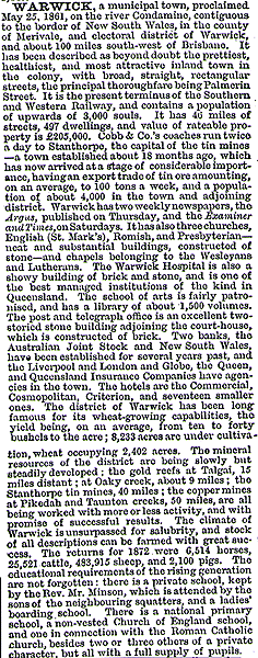
Warwick was connected by railway to Ipswich in 1871, and its fertile hinterland became well populated. The town’s wide streets were lined with substantial buildings made from the abundant local stone and clay for brickmaking. Well planted parks and recreation squares added to the town’s appearance. There was prosperous mixed farming around Warwick – wheat, grapes and wine-making, potatoes, oats, tobacco, dairying, butter and cheese-making, pigs and bacon curing. These activities were assisted by the subdivision of large pastoral estates, including Patrick Leslie’s famous Canning Downs Estate. The original Leslie house (c. 1846), is on the Register of the National Estate. The town’s enhanced amenities were described in 1904 in The Australian Handbook –

warwick2.gif

Two Warwick notables were Jackie Howe and Billy Hughes. Howe, born on Canning Downs Station in 1861, blade shore 321 sheep in one day. He was a gun shearer, and his other record with machine shearing stood until 1950. The Jackie Howe blue sleeveless singlet commemorates his fame. Prime Minister Hughes, when speaking on conscription in Warwick until 1917 and was hit by an egg. A police constable denied that he had power to arrest the assailant, provoking Hughes to establish the Commonwealth Police.

From 1861 to 1994 Warwick was an urban municipality. In 1935 it was made a City. Its position in the southern Darling Downs made it suitable as a place for boarding schools. In 1949 there were five private boarding schools, all taking boarders. Its civic festivals included an agricultural show, two race meetings a year and a Scots carnival on Boxing Day. In the 1990s the most prominent event is the Rose and Rodeo Festival. The climate is good for rose-growing, and the festival extends over most of October.

As well as schools, Warwick has a substantial shopping centre of about 150 shops, including the free-standing Rose City Shopping Centre. Woolworths also has a large national distribution warehouse in Warwick. The dairying hinterland supports the Dariyfields cheese factory.

In 1994 Warwick City was amalgamated with the Allora, Glengallan and Mulgrave Shires to form Warwick Shire.

Warwick’s census populations have been 5,248 (1911), 6,664 (1933), 9,303 (1971) and about 11,000 in 1994. Warwick shire’s population in 1994 was 20,600.

warwick1.gif


Postcard dated December, 1913.

Further Reading:

  • Hall, Thomas, The Early History of Warwick District and Pioneers of the Darling Downs, Toowoomba, 192?

Surat

Surat is a town on the Balonne River, about 500 km. west of Brisbane and 80 km. south of Roma. The town of St. George, about 116 km. southwards, is also on the Balonne River.

The district was first mapped by Surveyor-General Sir Thomas Mitchell in 1846. By the end of the 1849s pastoralists had penetrated the area, and in 1849 Mitchell directed a surveyor, Burrowes, to select a township site on the Balonne River. Burrowes did so and named it Surat, after his former place of residence in Madras Province, India. The town was appointed as a place for holding Courts of Petty Sessions, and a Police building erected. A hotel was opened in 1859 and there were seven buildings in the town by 1863. A school was opened in 1874. Surat had been the administrative centre of the Maranoa District until St. George superseded it in 1865. It remains the administrative centre of the Warroo Shire.

In 1872 Surat’s population was 108, and the district was mostly occupied by grazing (119,000 sheep and 21,000 cattle).

In 1879 a Cobb and Co. coach run was started from St. George to Surat and thence to Yuleba. The last coach run in Australia was from Surat to Yuleba (75 km.), on 14 August, 1924.

By the turn of the century Surat was a medium size town, as described in the 1904 edition of The Australian Handbook –

surat1.gif

While the carriage of perishable foods over long distances was difficult, Surat had local dairying and market gardens. A market garden was still recorded in the town directory in 1968. The Balonne river was a ready source of water, as well as occasional floods. It continues to be a source of good fishing. In 1951 reticulated water was supplied from a tower, to which treated water was pumped from a weir. In 1961 a new 16 bed hospital replaced the one built in 1929.

The town directory in 1968 included three churches, primary and secondary schools, two general stores, cafe, baker, newsagent, two butchers and the Astor picture theatre. In 1996 the shops were fewer but the theatre remained.

Surat is part of the name of a sedimentary natural gas basin – the Surat-Bowen Basin. Its best known production centre is the Moonie gas field, discovered in 1961.

In 1993 the dominant pastoral industry in the Warroo shire was sheep and lambs (485,000) followed nu beef cattle (53,000). Cereals were planted on 27,139 ha.

Surat’s census populations have been 582 (1911), 592 (1954) and 468 (1991).

Further Reading:

  • Armstrong, G.O., The Changing Years: A History of the Shire of Warroo, Warroo Shire Council, 1970.

Kwinana

Kwinana, on Cockburn Sound, is 23 km. south of Fremantle. Its name came from that of a State Shipping Service vessel, Kwinana, which was anchored at Careening Cove, Garden Island, which forms the western landmass of Cockburn Sound. The vessel had been damaged by fire and lay at anchor. When it was driven ashore by storm in 1922 at Kwinana, its resting place was given its name buy visitors and holiday cottage owners.

Kwinana is thought to be Aboriginal for “young women” in the Kimberley region.

The industrialisation of Kwinana began in 1951 when British Petroleum decided to build an oil refinery there. The refinery began operation in 1955. Broken Hill Proprietary (BHP) began building a steel rolling mill and further investment followed with reciprocal investment by the State Government. A Government railway was built to carry iron ore from Koobyanobbong, 430 km. east of Perth, for refining at Kwinana (1954-67). A railways marshalling yard and terminus occupying 12 ha. was built at Robbs Jetty in 1970. Other major industrial plants included the Western Alumina aluminium refinery (1964), Cockburn Cement (1965), fertiliser works (1969), the Western Mining nickel refinery (1971) and the State electricity generation station adjoining the aluminium refinery. Most large industries are at Kwinana Beach.

The Kwinana township is 4 km. inland from Cockburn Sound. It has been planned in segments, the first suburbs being Medina, Calista, Parmelia and Orelia. The Kwinana town centre is surrounded by the suburbs, and it contains the civic centre, arts centre, indoor recreation facilities and the Hub shopping area.

The development of Medina began in 1953 and on 15 February, 1954 the Kwinana Roads District was established. Housing was begun in 1954 by the State housing authority and a cinema, shopping centre and community hall were built by 1955. By the end of the decade there were a high school, a maternity hospital and a new railway line to Fremantle. Kwinana was proclaimed a shire in 1961, and an elected council replaced the Roads District Commissioner. In 1977 Kwinana was proclaimed a town.

A large proportion of the immigrants attracted to Kwinana were British. In the 1971 census 5,210 of Kwinana’s 12,224 residents were born in the United Kingdom.

The development of housing sites was controlled by the State Housing Commission, and the slow release of sites caused new residents to settle on freehold land outside Kwinana. The policy was modified in 1977 by the release of land at the Leda suburb, with involvement by private enterprise. Subsequently, older State housing has been refurbished by private developers.

The heavy industrial component of Kwinana has created a concern for ground water conservation, wetlands and community parklands. Equally, though, there is a concern for the preservation of employment opportunities in the region.

Kwinana has several pre-primary and primary schools and a state high school.

Kwinana’s census populations have been 2,801 (1954), 4,663 (1961), 12,224 (1971) and 17,278 (1991).

Further Reading:

  • Kwinana, Government of Western Australia, 1968.
  • Russell, Laurie, Kwinana “Third Time Lucky”, 1979.

Hay

Hay is a town and a shire in the Riverina region of New South Wales, 770 km. west of Sydney and 410 km. north of Melbourne. The area of the shire is 11,348 sq. km., and the other main town in Booligal. (Hence, “Hay, Hell and Booligal.”, A.B. Paterson’s poem remarking on the region’s extreme summer heat. “Hell” was One Tree Plain, 40 km. north of Hay. The locals dispute Paterson’s account of their summers.) The terrain is open treeless plains with eucalypts inhabiting the river country.

Hay is on the Murrumbidgee River, and at the junction of the Sturt and the Cobb Highways. The district was first settled in 1850 and a township was surveyed in 1859. First known as Lang’s Crossing the name “Hay” was given when the town’s design was approved in June, 1859. John Hay (later Sir), was the local member of Parliament. The wool produced in the district was transported by Murrumbidgee river boats from Hay. In 1872 a municipal council was proclaimed. Hay was connected by rail to Narrandera in 1882, to capture some of the river trade. (The line lasted until 1983, and the station is on the Register of the National Estate.) In 1881 The Australian Handbook described Hay as

…situated in the Riverine district, on the Murrumbidgee river. It is a shipping port and port of entry, 460 ;miles (493 postal) SW. of Sydney; the more speedy communication with which is via Melbourne to Echuca by rail, thence by Deniliquin and Moama railway, a distance in all of 275 miles.

To Sydney overland the route is by coach to Wagga-Wagga, thence the railway. Cobb’s coaches leave Hay for Deniliquin daily, and on Tuesdays and Saturdays for Wagga-Wagga, Wednesdays and Sundays for Bolligal, &c. It is in the county of Waradgery, police district of Hay, and electorate of Balranald, returning two members. In the municipal district are 21 miles of streets, and property of the annual rateable value of L24,185.

It is an important crossing place, by a fine iron bridge on the Murrumbidgee river, which is navigable to here by steamers during the greater part of the year. This bridge is 400 yards in length, with a swing to enable steamers to pass in food seasons. The river is navigable to Wagga-Wagga (470 miles) during a greater portion of the year. The highest rise in the river above summer level ever known here has been 24 feet.

The leading hotels are the Tattersall’s, Caledonian, Commercial and Crown. The Hay Standard, weekly, and Riverine Grazier, biweekly, are the local journals. The Episcopalians, Presbyterians, Roman Catholics, and Wesleyans, have places of worship here; there is also a hospital, Athenaeum and free library. Banks: N. S. Wales, Union and Joint Stock.

The premises of both the N. S. Wales and joint Stock Banks are fine spacious buildings. Insurance Agencies: Sydney, Alliance, United Victoria, Mutual Life Association, and Austsralian Widows’ Fund. Principal buildings, besides those mentioned, are the court-house, post and telegraph office and police barracks, public school, Masonic hall and theatre, municipal chambers, and gaol. There are at hay Masonic, Foresters’ and Temperance lodges, lands office, three breweries, and a bonded store.

The town is supplied with water from the nunicipal waterworks, the water being pumped up from the river and carried in pipes through all the principal streets. The town is well laid out, the streets are broad, in some cases planted with trees, and the footpaths asphalted.

The surrounding country is entirely taken up for sheep and cattle stations, and consists of plains sparsely timbered. The population is now stated at upwards of 2,000, and the district at upwards of 4,200. About 70,000 bales of wool are sent from Hay during the season.

The Hay gaol was built in 1879 and is on the Register of the National Estate. For want of prisoners it has been used as an emergency hospital (Spanish Influenza epidemic, 1919), a Red Cross Maternity Home, and hospital for a Prisoners of War camp and as a postwar Institute for Girls. In 1976 it was made into a museum.

In 1994 the Hay Shire had 675,000 head of sheep and fat lambs, 67,000 cattle and 25 sheep stud establishments. Farming was predominantly grazing, with small areas of cereals, rice growing and market gardens. The Hay township had five manufacturing establishments in 1994, and its position on two highways gave it nearly $1.5 million in accommodation takings through seven hotels/motels. The aerodrome, 3 km. south of Hay, has night landing facilities. The township has four banks, a high school and primary schools, a student’s hostel, the weekly riverine Grazier newspaper and a full array of community and recreational facilities. Hay won the N.S.W. Tidy Towns State title in 1991.

The populations of Hay have been 2,461 (1911), 3,156 (1933), 4,349 – shire, 2,817 – town (1971), and 3,808 – shire, 2,817 – town (1991).

hay1.gif


Postcard dated December, 1907.

Further Reading:

  • Hay Historical Society, “The Witcombe Heritage: A History of the Buildings of Hay”, 1993.
  • “Hay Information Booklet”, 1983.

Currie

Currie is the administrative and commercial centre of King Island, the western-most island in Bass Strait. Currie is on the west side of the island, occupying a harbour which is protected by an extensive breakwater. It was originally named Howie’s Boat Harbour after David Howie, an early visitor and unofficial resident of the island in the 1840s. It was renamed after Archibald Currie (1830–1914), a shipowner who purchased the remains of the Netherby wrecked near there in 1866, and used the harbour as a base for salvage operations. The harbour was used for similar operations on later wrecks in the vicinity including the ”British Admiral” in 1874 and ”Blencathra” in 1875, the latter being wrecked right at the entrance to the harbour.

The town’s civic institutions include the hospital, King Island District High School (to year 10), the museum, four churches, Council chambers and the town hall. There are golf, bowling, tennis and other sports facilities. The commercial centre include airline agencies, hotel, restaurants, shops specialising in King Island foods and produce and the usual range of supermarket, newsagent’s and pharmacist’s outlets. The Parer Hotel is named after the Parer family, the island’s first hoteliers, from whom Ray Parer (aviator) and Damien Parer (war photographer) were descended.

Local industries are fishing (for which the harbour has a wharf), food processing, tourism and a kelp factory. The kelp is harvested after it is washed up after westerly weather, and milled for export to Scotland. The extract is used in over one-thousand food, cosmetic and other products. Kelp harvesting began in the early 1970s, and has helped to offset unemployment from the closed scheelite mine at Grassy.

A short distance north of Currie are the racecourse, abattoir, aerodrome and the King Island cheese factory. Much of the meat from the abattoir is exported to Japan.

Electricity is generated by a diesel plant and by wind-driven apparatus installed in 1998.

The census populations of Currie have been 215 (1911), 678 (1954), 819 (1991).

currie2.jpg


Main Street, Currie, King Island, Postcard dated c.1910

Further Reading:

  • Edgecombe, Jean, “Discovering King Island, Western Bass Strait”, the author, 1993.
  • Hooper, R.H., “The King Island Story””, Peko-Wallsend Ltd., 1973.
  • Wood, Michael, “Story of King Island, King Island Quik Print, 1990.

Grassy

Grassy is a former mining township on the east coast of King Island in Bass Strait. The name is descriptive of the place.

In 1911 a prospector found a mineral specimen which he thought contained tin but which was scheelite, a tungstate of calcium. The King Island Scheelite Development Company NL began treating ore in 1917, and continued for three years. The mine was revived in 1937, and open-cut mining supplied tungsten for hardened steel during the second World War and the postwar years.

A company town was developed. In 1966 it had 135 company dwellings, a hall, a cinema, sports facilities, a golf course and a workmen’s club, for a population of 540, of whom 170 were employed by the company. Water was reticulated from two reservoirs on the Grassy River. A school was provided, which had one hundred pupils in 1966.

Overburden from the mine was used to construct a breakwater for the Grassy harbour and to widen the shoreline beyond the mine.

The harbour can take cargo vessels, and is used to run the annual Queenscliff to Grassy yacht race. Fuel is imported in bulk from vessels to tanks at the Naracoopa jetty, twelve kilometres northwards.

The scheelite industry is ruled by world export prices and in 1990 falling prices resulted in the closure of the mine. The town was evacuated of most of its population. Several houses were removed to other population centres, some have become derelict and a small population resides in the rest. A general store services the local community and the school buildings are used for community purposes. The harbour is still used (1998), but the open cut mine is filling with water.

Grassy has attractive forested land around it, in contrast to the undulating grassland on the sandy west side of King Island. Narcoopa and Yarra Creek Gorge, north of Grassy, have considerable scenic value with holiday facilities and some permanent residents. Naracoopa is the site where a New South Wales exploring party met the French Baudin expedition in 1802 and took possession of King Island. It has also been the site of sand mining, evident form the blackish shoreline immediately northwards.

Grassy’s census populations have been 87 (1921), 352 (1947), 767 (1971) and 253 (1986).

Further Reading:

  • Edgecombe, Jean, “Discovering King Island, Western Bass Strait,” the author, 1993.
  • Hooper, R.H., “The King Island Story”, Peko-Wallsend Ltd., 1973.
  • “King Island Scheelite Mine, Grassy, King Island, Tasmania 1937-1966”, King Island Scheelite (1947) Ltd.

Cockatoo Island

Cockatoo Island is in Sydney Harbour, 10 km. from the Sydney Heads and 4 km. west of the Harbour Bridge. It faces Balmain and Hunters Hill and its area is 18 ha.

In 1839 excavations were made in the Island’s sandstone for the construction of wheat silos. The stone was also hewn for building works such as the Circular Quay wharf, and over the years the elevations of the island was reduced by about three metres. The island’s area was also increased by about one-third to its present size. In 1839 a penal establishment wa placed there.

Nautical activities gradually displaced the prison, which closed in 1908. In 1857 the Fitzroy dry dock was built, and the Sutherland dry dock in 1890. Workshops for the building and repair of ships were also established. The New South Wales Government installed and added to engine shops, slipways and cranes between 1904 and 1908, and the Commonwealth Navy placed contracts there for ship building. In 1913 the Commonwealth Government took over Cockatoo Island as a defence establishment.

The first world war brought more work, including repairs to submarines. The workforce in 1915 totalled 2,800, of whom 1,550 were in the shipyard. In 1920 it was nearly 3,300. Later during the 1920s ship-building work declined, and by 1933 the workforce was about 300. A court judgement had greatly restricted the Government’s scope to take in private work, so the dockyards was leased to the Cockatoo Docks and Engineering Company Ltd.

The onset of the second world war brought ship-building in addition to repair work, and reconditioning became a major work in the post war years. Vickers Limited obtained a majority shareholding in the lessee company in 1947. In 1962 the world’s largest roll-on, roll-off merchant ship, Empress of Australia (12,037 gross tons), was built at Cockatoo Island. The dockyard continued to be the sole submarine refitting site in Australia.

In 1976 the dockyard was overlooked when tenders were called for the building of naval destroyers, but the workforce stood at 2,250 with 400 apprentices. In 1987 the Commonwealth Government concluded the lease of the dockyards, which was closed down in 1992.

Further Reading:

  • Parker, R.G., “Cockatoo Island”, Nelson, 1977.
  • Stringer, Michael, “Sydney Harbour”, pages 116-130, J.M.O. Stringer and Co., 1984.

Temora

Temora is 325 km. west of Sydney, 90 km. north of Wagga Wagga and in the north-east of the Riverina district.

Temora was the name of an early pastoral property, and was derived from an Aboriginal word of uncertain meaning or from a Scottish Gaelic tern meaning an eminence with an extensive view. The Temora pastoral station was gazetted in 1849, occupying 200,000 acres.

Unpayable quantities of gold were found on the Temora station in 1869, and the discovery of payable gold did not occur until 1880. A small village formed by April, 1880. By the middle of 1880 there were 20,000 people in the Temora district and the town site was surveyed. The next few years saw the winning of gold (alluvial and reef) and prolonged drought. By 1885 Temora had a hospital and three churches. In 1888 most of the Temora station was subdivided for small-farm settlement. Three years later the Temora town council was created and the railway reached Temora in 1897. A well-established Temora was described in The Australian Handbook, 1904, as –

temora1.gif

In 1912 the town electricity supply was established and an agricultural research station opened. It concentrated on pasture, wheat and oat growing and sheep research. On the eve of the first world war the Star Theatre was opened and in 1925-6 the Literary Institute and School of Arts were opened. The benefits of the Burrinjuck Dam on the Murrumbidgee River, 120 km. to the east came in 1930 with the supply of hydro electricity and in 1935 with a town water supply. The swimming pool was opened in the same year, and a sewerage scheme built four years later.

Temora, with a municipal area of 21 sq. km. was described in the 1949 edition of The Australian Blue Book as –

temora2.gif

In 1952 the Temora High School was opened and in 1971 a large pre-school premises was built. A reduction in secondary industry (the cordial factory closed in 1979) was partially relieved by tourism and the town’s historical society embarking on a rural museum in 1979. An extensive group of buildings was acquired, including Sir Donald Bradman’s original home. The township also contains several substantial buildings, a notable one being the Sacred Heart Catholic Church.

In 1969, on the property of harness-racing horse breeder, Colin Pike, a colt named Paleface Adios was born. The horse became the Pharlap of harness racing over an eight year career that ended in 1980. Temora has a memorial to “The Temora Tornado, Paleface Adios.” In 1981 the councils of Temora (town) and the surrounding Narraburra shire were united to from the Temora shire of 3,752 sq. km. The district’s gold mining past was revived when the Paragon open-cut gold mine was begun in 1987, about 12 km. north of Temora at Gidginbung. Temora has seven hotels and one hotel/motel. In 1994 the Temora shire had 120,494 ha. under pasture, 34,683 ha. growing wheat and 574,000 sheep and lambs.

Temora’s census populations have been 2,784 (1911), 3,823 (1931), 4,446 (1971) and 6,200 (1991 – enlarged shire). The town’s 1991 population was 4,279.

Further Reading:

  • Goffin, Graham, Paleface Adios, The Living Legend, Harness Racing Publications, 1982.
  • Temora Yesterday and Today 1880-1980, Temora Historical Society Inc., 1992.

Jamieson

Jamieson, a rural township and agricultural district is at the junction of the Goulburn and Jamieson Rivers, in country with river flats. It is 30 km. from Mansfield and 120 km. north-east of Melbourne.

Jamieson was a goldfield and a supply centre for gold fields in a belt of country running southwards to Walhalla. Prospectors successfully penetrated the area in 1860, and in 1861 the Jamieson gold workings had over 300 people. A town site was surveyed in 1862 on the river flat encircled on three sides by the Jamieson River. It was probably named after a shepherd, George Jamieson, who grazed sheep there during the previous decade, although a squatter William Kerr, West Gippsland, has been suggested as having inspired the name.

By 1865 Jamieson had a borough council (1864), a Catholic chapel, an Anglican church, a school, a court house and police camp, branches of two banks and two insurance offices, five hotels and several stores. Balliere’s Victorian Gazetteer described it as the entrepot to the Woods Point and other diggings. In 1865 the first Jamieson and Upper Goulburn race meeting was held.

The 1870s were golden years for Jamieson, but the following decade saw a sharp decline in gold production. Howqua shire superseded the borough in 1874, extending municipal government to Gaffneys Creek, 20 km. southwards, and to the intervening small settlements of Kevington, Ten Mile and Knockwood. The shire offices, however, were in Jamieson. Gold production continued fitfully until the first decade of the twentieth century, and yielded increasingly meagre returns until many mine workings were destroyed in the 1939 Ash Friday bushfires. Howqua shire was united with Mansfield shire in 1919.

In 1903 The Australian Handbook described Jamieson –

jamieson1.jpg

Since the development of tourism in the Lake Eildon region, Jamieson has gained from providing rural-retreat and motoring holidays. It has two hotel/motels – the Court House and the Junction – a caravan park and several restaurants/bed-and-breakfasts. Saw milling has also assisted the local economy, and farming extends about seven kilometres eastwards along the valley of the Jamieson River. Fishing in the streams has a strong following. Amateur gold dredging in the Jamieson River has occurred since the 1980s.

The Jamieson court house (1863) is on the Victorian Heritage Register.

Jamieson’s census population were 389 (1871), 237 (1901), 157 (1947) and 128 (1966).

Further Reading:

  • Lloyd, Brian, “Gold at the Ten Mile: The Jamieson Goldfield”, Shoestring Bookshop, 1978.

Buchan

Buchan is located twenty-six kilometres north of Nowa Nowa on the Princes Highway and 330 kilometres east of Melbourne. The township lies in the valley of the Buchan River hedged by rounded limestone hills.

Pastoralists first entered the area in the late 1830s. Buchan station, taken up in the 1840s, had a succession of owners. To the north were the Galantipy and Black Mountain runs. The name Buchan is thought to be taken from an Aboriginal word Bukkan-mungie to which various meanings have been ascribed. One interpretation is place of grass bag. There were small groups of Aboriginals in the area but their numbers declined rapidly after European settlement. In 1861, Rev. John Bulmer inspected land south of Buchan as a possible site for a mission station. When he moved to Lake Tyers, the remaining Aboriginals accompanied him there. At Cloggs Cave near Buchan, evidence has been found of Aboriginal occupation in prehistoric times.

Land settlement began in 1870, with the best land along the river quickly taken up. A township was proclaimed in 1873, taking its name from the station. The Victorian Municipal Directory described the district in 1888.

BUCHAN.- A mining and postal village with telegraph station, 230 miles E. of Melbourne, situated on the Buchan river. The district is suitable for grazing and mining; it is famous for its scenery and extensive caves. Population, 85.

There was some interest in mining from the earliest days. Over the years, many companies were formed, mainly to mine silver, lead and gold. A few larger mines were profitable but most were shortlived. Marble had been quarried in the 1860s to build the Murrindale Park homestead. Commercial quarries operated from the early 1900s. Black marble from Buchan has been used at the Shrine and State Library in Melbourne as well as buildings in London, elsewhere in Victoria and other states. From the 1950s a quarry also produced crushed lime for agriculture, paper manufacture and other uses.

The existence of the limestone caves was well known. In the 1880s the journalist ‘Tanjil’ described them in his Guide to the Gippsland Lakes and Rivers. But it was not until 1889 that they were surveyed. Development was recommended but it was 1900 before a local man, Frank Moon, was appointed as caretaker of the caves reserve. Moon explored most of the caves in the district, discovering the Fairy Cave in 1907. this dry cave with fine formations was opened for public inspection the following year. Royal Cave was opened in 1912 and by 1917 there were six caves open. Buchan became popular with tourists, who generally stayed several nights at one of the local guesthouses or hotels. In the 1920s, camping facilities were developed near the caves and regular bus tours began to visit.

On the river flats, crops such as wheat, oats and barley were being grown, as well as some hops, maize, arrowroot and beans. Some dairying was carried on, at first for local consumptionm. Around the turn of the century, several cheese factories were established on larger farms and a butter factory operated for some years. In the 1970s milk was sent by tanker to Maffra. Sheep and cattle grazing increased as settlement spread. Cattle sales began in Buchan about 1901. Closer settlement of the farming land meant more demand for services, so that by 1938 the Victorian Municipal Directory described a settled township.

BUCHAN – Township on Buchan river with post, telegraph and money-order office. State school, police station, mechanics’ institute, hotel, boarding-houses, branch of bank, store and butter factory. Remarkable caves in district, notably – The Fairy, Kitson, Spring creek, Moon (with an ice-cold lake containing small blind fish), King’s Slocomb’s, Wilson’s and others. Lead mines on Back creek and Murrindal river. River flats cultivated. Rail to Nowa Nowa; motor at 5.35 p.m., 20 miles; fare, 12s. 6d. Population, 100. SOUTH – Motor, 16 miles from Nowa Nowa; fare, 10s 6d.

Wattle bark stripping was an important industry and small spot mills worked in the surrounding forest. Since the Second World War, two large sawmills have operated at Buchan, providing secure employment.

The caves were closed during the war years, reopening in 1946. In 1984 the Shades of Death Cave at nearby Murrindal was opened for public inspection and adventure cavers explore many of the wild caves in the area. Today over 100,000 people visit the caves annually. The spectacular scenery of the nearby Snowy River, whitewater rafting and trail riding also bring tourists to the area. Also there are three alternative lifestyle communities north of buchan. The Victorian Municipal Directory describes Buchan in 1994.

BUCHAN – Township of Buchan, with post, telegraph and money order office, State school, police station, mechanics’ institute, hotel, motel, store, three churches, kindergarten and infant welfare centre. Remarkable caves in district, notably the Fairy and the Royal. Lead mines on Bach Creek and Murrindal River. River flats cultivated. Population -250. 26 km from Nowa Nowa. 330 km from Melbourne. Postcode 3885.

Sawmilling, tourism and farming have supported a steady increase in population. Services have improved and social and sporting organisations flourished. Buchan’s dependence on the timber industry is reflected by the importance of its annual axemen’s carnival. Another popular event is the picnic race meeting at Canni Creek, south of Buchan where a racecourse has been carved out of the forest.

buchan1.jpg


Circa 1930
(Centre for Gippsland Studies, Monash University, Gippsland)

Further Reading:

  • Adams, J., “The Tambo Shire centenary history”. 1981.
  • “Buchan School no. 1905”: a brief history of Buchan district and schools prepared for the Buchan School Centenary. 1977.
  • Buchan Sesquicentenary Committee, “Bukan-Mungie: 150 years of settlement in the Buchan district – 1839-1989”. 1989.