
Aberfeldy is on Mount Lookout in the Great Dividing Range, on the ridge between the Thomson and Aberfeldy Rivers, about 75 kilometres north of Moe and 125 kilometres east of Melbourne.
Gold had been discovered throughout the area, with rushes occurring on the Jordan River in 1859, at Gaffney’s Creek in 1860, at Wood’s Point and Matlock in 1861, on the Aberfeldy River and Donnelly’s Creek in 1862 and on Stringer’s Creek (later Walhalla) in 1863. After initial alluvial mining, goldbearing reefs were discovered. And in 1871, the first reef on the ridge was opened up.
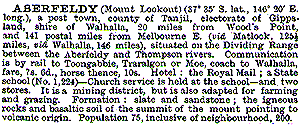
A township, first known as Mount Lookout, was soon established. The name Aberfeldy is from a Scottish town. There were soon hotels, stores, bakers and butchers. A school was opened in 1872. The Australian Handbook of 1875 described the town thus:

The soil was fertile so potatoes and other crops were grown. Some sheep and cattle were grazed and pigs kept within rock fences. However few of the mines realised expectations. There was a revival in the 1890s but the township decreased considerably in size, as shown by the 1904 Australian Handbook entry.
A couple of companies were still doing well at the beginning of the First World War. In 1913 the population was about 70. Although this was reduced by the end of the war, the town still survived, focussed around the remaining hotel. However this burnt down in 1938 and most of the town buildings were destroyed by bushfires in 1939. A guesthouse with tennis courts and swimming pool was built in 1941 as a tourist development, but this was not successful. By 1950 a road was constructed through to Matlock, but even today access is poor with only a gravel road, narrow and winding in parts.
A landmark on the roadside near Aberfeldy is Kitty Cane’s grave. A former dance hall girl and owner of a shanty, Kitty Cane was believed to have weighed over 120 kilograms. When she died, the miners could only carry the coffin for a short distance, so she was buried beside the track.
There are a few permanent residents in the area. Some chimneys and stone fences remain and the site of the old hotel is recognisable. The cemetery is bleak and windswept but has panoramic mountain views, at one of the highest settlements in Victoria.

Mt Useful from Aberfeldy, circa 1930.
(Baragwanath Collection, Centre for Gippsland Studies, Monash University, Gippsland)
Further Reading:
- Adams, J. “Mountain gold: a history of the Baw Baw and Walhalla country of the Narracan Shire, Victoria”. Trafalgar, Narracan Shire Council, 1980.
- Steenhuis, L. “Ghost towns of the mountain goldfields: upper reaches of the Yarra, Goulburn, Latrobe and Thomson watersheds”. 1994. Manuscript.
- Tomlin, O.F. “Gold for the finding: a pictorial history of Gippsland’s Jordan goldfield”. 1979.
Related
-

We should all name and shame
In any society there has always been behaviour that is legal but undesirable. In the past this was discouraged by the close community bonds that existed that most valued and were fearful to jeopardise. Unfortunately those bonds are breaking down. My startup is working to remedy that by introducing functionality to “name and shame” individuals … Continue reading “We should all name and shame”
-

There is no logic in lockdown
Crunching the figures and applying logic to determine the actual “benefit” of lockdown
-
take 3 on free art ;-)
Ben can I please have some free art?


my ancestors were miners in woods pt, then 1875 aberfeldy-honora waterstreet had 13 children-she ran two hotels in her day –a tough woman
I also am connected to Paul’s family, Charles WATERSTREET and his wife Honora nee RYAN, through their 2nd daughter Amy who married into my SWETNAM family, all in Wood’s Point. Would love to make contact with Paul.
hoping you see this sue as i have a heap of info on the swetnam family -sister-eh!-paul-w(paulwaterstreet@yahoo.com.au)
Woods Point Museum has lots of photos and up dates from people who come to visit, usually trying to trace family history or add to stories that are already known. Any photos of anything to do with Woods Point or Aberfeldy are always very welcome!
Oh..my 2011..and I’ve just noticed?..sorry Tony..
I only just saw this Tony. Amy waterstreet to Eugene t.swetnam 2nd marriage..give me hello on facebook